|
Arctic and Antarctica
Reference:
Vasil'chuk, Y.K. (2025). The concentration of major soluble ions in the ice core of the pingo at the Pestsovoye gas field, in the Evoyakha River valley of southern Tazovsky Peninsula, Northwestern Siberia. Arctic and Antarctica, 2, 35–55. . https://doi.org/10.7256/2453-8922.2025.2.74286
The concentration of major soluble ions in the ice core of the pingo at the Pestsovoye gas field, in the Evoyakha River valley of southern Tazovsky Peninsula, Northwestern Siberia
Vasil'chuk Yurii Kirillovich
ORCID: 0000-0001-5847-5568
Doctor of Geology and Mineralogy
Professor, Lomonosov Moscow State University, Faculty of Geography, Department of Landscape Geochemistry and Soil Geography
119991, Russia, Moscow, Leninskie Gory str., 1, office 2009

|
vasilch_geo@mail.ru
|
|
 |
Other publications by this author
|
|
|
DOI: 10.7256/2453-8922.2025.2.74286
EDN: FTUSYM
Received:
30-04-2025
Published:
15-05-2025
Abstract:
The author describes more than 20 pingos at the Pestsovoye gas field, located 10-15 km north of the Tundra station, 98-103 km from the town of Novy Urengoy. The investigated pingo's height ranges from 15 to 20 meters, and its diameter is 150 to 200 meters. Most often, the profile of these formations features a lower part – a pedestal, approximately 5-7 m high—over which the main hill rises in a dome-like shape. More thorough dating of the overlying peat was done on one of the 17-meter-tall hills, which is 10 kilometers north of the Tundra station (29–30 kilometers after the turn to Pestsovoye from the main highway leading from Novy Urengoy). The results showed that these pingos formed relatively recently, at least not earlier than 2,500 years BP. This timing suggests that the geological processes leading to their formation may have been influenced by climatic changes in the region. Understanding the age and development of these structures can provide insights into past environmental conditions and inform predictions about future landscape evolution in response to ongoing climate shifts. Peat covering the middle part of the hill and the area close to the pedestal's base was sampled in order to establish the pingo's age. In the winter of 2013, ice samples were taken from the pingo core. With a detection limit of 0.02 mg/L for chloride ions, the ion chromatograph "Stayer" (Russia) was used to measure the macro-component composition of the ice. Radiocarbon dating of the peat showed a relatively young age of the overlying peat in different parts of the hill. In the central part of the pingo, surface peat is dated at 2560 ± 70 BP, peat from a depth of 0.3-0.4 m is dated at 5220 ± 50 BP, and peat from a depth of 0.85-0.9 m has an age of 5080 ± 50 BP. On the pedestal, peat from a depth of 0.05-0.15 m is dated at 5400 ± 40 BP. In the ice core of the pingo were determined ions of potassium, sodium, calcium, magnesium, chlorine, sulfates, and nitrates. Among the anions, the chlorine ion predominates (from 0.6 to 3.3 mg/L), followed by the sulfate ion (from 0.3 to 1 mg/L). The ratio of chlorine ions to sulfate ions varies from 0.7 to 3.7, averaging 1.7.
Keywords:
soluble ions, anions, cations, macroelements, pingo, ice core, permafrost, Evoyakha River, Pestsovoe, northwestern Siberia
This article is automatically translated.
Introduction The macronutrient composition of underground ice is formed by the combined influence of the ionic composition of the waters that formed these ices and the macrocomponent composition of the sediments containing the ice. For example, the underground ice in the kimberlite pipes of western Yakutia has a different ionic composition due to the fact that their host rocks contain significantly different amounts of anions and cations.[1,2] Bulgunniakhs (synonym pingos) can be under significant pressure, leading to explosive destruction [3]. N.S.Bogomolov and A.N.Sklyarevskaya[4] described a case when large fragments of ice up to 0.7 x 1.5 x 2 m in size were scattered over a distance of 2-8 m, and smaller ice fragments on the the distance is up to 20 m. The explosion was accompanied for 30 minutes by the release of a jet of water up to 1.5 m high. According to Ross McKie's observations, non-flammable gases are released from some pingos along with a small amount of water.[5] In 1825, J. Franklin made the earliest description of pingos when he climbed a small pingos on Ellis Island in the Mackenzie Delta. In 1938, the term pingo was first borrowed from the local population by the Arctic botanist A.E. Porsild in his article on the pingo of the western Arctic coast of Canada and Alaska (pingo Porsild in So the mouthpiece is named after him). The term pingoe, which means a conical hill among the Indians, is now accepted as a scientific term in English literature. The age of pingos in two areas on Banks Island, Canadian Arctic, 150 km apart, is estimated by radiocarbon dating to be approximately 4,500 to 7,000 years old. Such datings support the view that pingos grew during the cold snap at the beginning of the Holocene. Dating of the Pingo deposits in Svalbard, the Mackenzie Delta, and Alaska gave only an idea of the maximum age, almost everywhere it was the Holocene. Data on the minimum age of pingos, with the exception of the youngest forms, are generally scarce, but it can be assumed that it is the first thousands and even hundreds of years. The highest annual growth rate of pingos, as determined by Ross McKie, was 21.2 cm/year. In the first year or two of development, a rate of up to 1.5 m/year is possible, but later it decreases in proportion to the square root of age.[5] According to Ross McKay's observations, the vertical growth rate of one of the pingos, at the top of which a dilatation crack 0.5-1.5 cm wide and 15-18 m deep was opened, was approximately 15 cm/year during 1969-1971. In the Mackenzie Delta, pingos with a height of about 6 m are known, which were formed after 1935 following the retreat of the shore, which caused the lake to descend. Other pingos arose after 1950. According to V.N.Sukachev, the age of a number of pingos in Siberia ranges from 106 to 162 years. E. Bibus mentions radiocarbon dating of 1875 ± 470 years ago, interpreted by him as the minimum age. He also points to X.According to Svensson, the figure is 2,400 years old, although X.According to Svensson[6], this date is 2650 ± 55 years old and is cited as the maximum age. In relation to the Ibyuk Ping, the tallest in Arctic Canada (over 50 m high, this ping is classified as a national landmark of Canada), rated F.Muller[7] is presumably no older than 7,000-10,000 years old, studies show that it continues to grow in height, by about 2 cm per year, and calculations based on growth rates in 1973-1975 give reason to believe that its age is about 1,000 years.[8] E.Olson and W. Brecker[9] based on the sample of B.Craig, taken in 1955 from the peat base from a depth of 0.9 m at the peak of Pingoe in the valley of the Telon River (64° 19' N, 102° 41' W), the Northwestern Territories of Canada received 14 C dating 5500 ± 250 (L-428). In the zone of almost continuous permafrost distribution and in the north of the more southern permafrost zone, injection mounds of heaving are widespread, which are divided into hydrolaccoliths and bulgunniakhs. In 1932, N.I.Tolstikhin showed that long-term heaving mounds are formed in the areas of the outlet of ascending sources and coined the term “hydrolaccolites” for such forms.[10] Hydrolaccolite is a convex mesoform of relief up to 25-30 m high and 250-400 m in diameter, composed, as a rule, of clay soils, resulting from the upward development of permafrost rocks as a result of the introduction of pressurized groundwater and the formation of a powerful injectable ice core. Bulgunniakhs are most often located in areas of recent tectonic uplifts, in various parts of the zone of continuous permafrost distribution. They are located in the south of Yamal, in the north of the Gydan Peninsula, and have been studied in detail in the Yarudey basin (within the Eagle structure) and in the south of the Taz Peninsula (Samburgskaya structure).[11,12] The Yakut term "bulgunniakh" referred to small isolated natural hills, regardless of their genesis. It has been observed that bulgunniaks sometimes gradually grow among the lowlands, and fossil ice is found in their core. These gave reason to consider the bulgunniakhs to be the result of heaving, and hence to use the name "bulgunniakh" only to designate long-term heave mounds.[13] The purpose of this work is to study the composition of the main soluble ions in the pingo (bulgunnyakha) core at the Pestsovoye deposit, in the Evoyakha River valley, south of the Taz Peninsula to determine the source of ice formation; Objects and methods The author studied the hydrochemical composition of ice exposed in the core of the pingoe (bulgunnyakha) at the Pestsovoe deposit, in the valley of the Evoyakha River (Fig. 1), in the south of the Taz Peninsula.[14,15,16,17,18,19] 10-15 km north of the Tundra station (29-30 km after turning to the Pestsovoye gas field from the main highway), 98-103 km from Novy Urengoy (66°10' n. 76-77° east), we encountered more than 20 bulgunniakhs (Fig. 2). The height of the studied bulgunniakhs varies in mainly from 15 to 20 m, the diameter is 150-200 m.
Most often, the lower part stands out in their profile – a pedestal, about 5-7 m high, above which the main hillock domes (see Fig. 2, a). 
Fig. 1. Location of bulgunnyakh at the Pestsovoe deposit, in the valley of the Evoyakha River 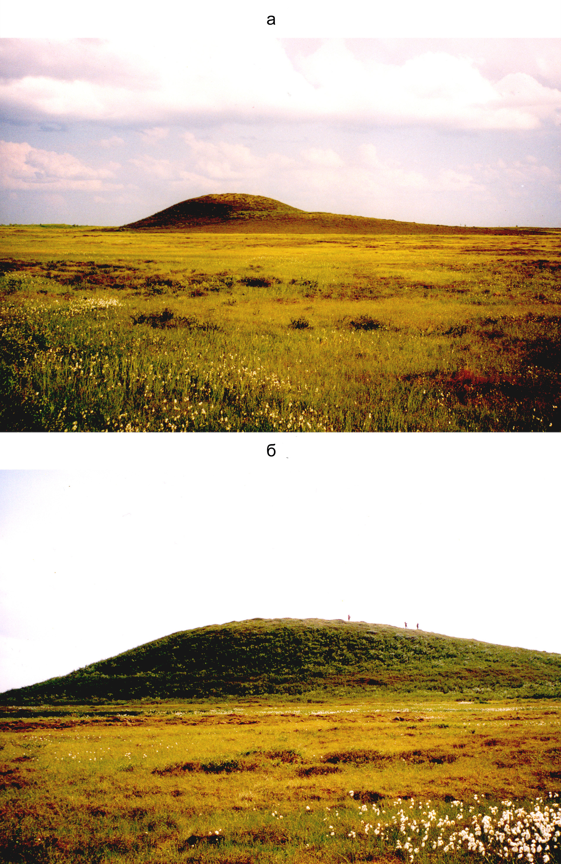
Fig. 2. Bulgunniakhs in the area of the Pestsovoye deposit in the south of the Taz Peninsula: a – with a pronounced pedestal, b – with a height of 17 m on top of which samples for radiocarbon determinations were selected On one of the hillocks, 17 m high, 10 km north of Tundra station (29-30 km after turning onto Pestsovoe from the main highway from Novy Urengoy), a more detailed survey was performed (see Fig. 2, b). For this purpose, samples were taken from 3 pits on the top and slope of Bulgunnyakh for radiocarbon determinations, and in the winter of 2013, a well was drilled to a depth of 30 m (Fig. 3) to study the internal structure of the ice core and to take samples for isotope-hydrochemical determinations. Powerful ice lenses in the cores of the Bulgunniakhs are also found in other areas of the Taz Peninsula (Fig. 4).[20] 
Fig. 3. Drilling of bulgunnyakh at the Pestsovoye field, in the valley of the Evoyakha River The incision of the hillock (fig. 4, a) has been opened: 0.0-0.5 m. Peat is dark brown. 0.5- 0.9 m. The loam is detached dark brown. 0.9- 12 m. The loam is dark gray and dense, with layers of calcification. The cryotexture is massive. In the lower part, from a depth of 10.2 m, powerful (up to 5-7 cm) horizontal ice sheets were encountered. 12-12.7 m. Interbedding of loam and ice, the thickness of the ice layers is 5-7 cm, the loam is 10-12 cm. 12.7-27 m. Interlacing of cloudy, transparent, and milky-white ice (Fig. 5). In the range of 20-22.5 m and 26-27 m, there are interlayers of loam 2-3 cm thick. 27-35 m . The loam is dense and gray, and the cryotexture is indistinctly layered. Ice layers 5-8 cm thick were found at depths of 27.8, 28.5, and 31.8 m. 
Fig. 4. Powerful ice lenses in the Bulgunnyakh cores in the south of the Taz Peninsula: a - the peak of the studied Bulgunnyakh, 17 m high in the area of the Pestsovoe deposit, 10 km north of Tundra station, b – from the Geocryological conditions of the West Siberian gas–bearing province[20]: c – the peak of Bulgunnyakh, with a height of about 15 m on the left bank of the river.The Khadutte and b–bulgunni rivers (about 7 m high) with a hummocky polygonal tundra between the rivers Tabyakha and Yenyakha: 1 – loam; 2 – peat; 3 – plant remains; 4 – injectable ice; cryogenic texture of highly silty sediments: 5 – lenticular and often lined, 6 – basal 
Fig. 5. Core of the Bulgunnyakh ice core (from a depth of 12 to 27 m) at the Pestsovoye deposit in the Evoyakha River valley Sampling and sample preparation To determine the age of bulgunnyakh, peat was tested covering the hillock in the central part and near the foot on the pedestal. Ice samples from the core of Bulgunnyakh were taken in the winter of 2013. Laboratory methods The macro-component composition of the ice was measured using a Steyer ion chromatograph (Russia), with a chloride ion detection limit of 0.02 mg/l. The Steyer ion chromatograph is designed for qualitative and quantitative determinations of inorganic compounds F-, Cl-, NO 3-, NO 2-, SO 4 2-, PO 4 3-, Na+. NH4+, K+,Mg2+, and Ca2+ in aqueous solutions of various origins (natural, industrial, and potable). For ice from the core of Bulgunnyakh, a method was used to measure the mass concentration of Ca2+, Mg2+, Na+, K+, NH4+ cations in samples of drinking water, mineral, natural and waste water by ion chromatography FR.1.31.2005.01738. The range of detectable concentrations is 0.10-20.00 mg/dm3, and for the determination of anions, a method was used for measuring the mass concentrations of Cl-, SO4-, NO3- in samples of drinking water, mineral, natural and wastewater by ion chromatography FR.1.31.2005.01724, the range of detectable concentrations is 0.10-20.00 mg/dm3 and a method for measuring the mass concentration of ions in samples of natural, drinking and wastewater by ion chromatography HDPE F 14.1:2:4. 132-98. The range of determined concentrations for cations is 0.10-150.00 mg/dm3. Radiocarbon dating of peat was performed at the Geological Institute of the Russian Academy of Sciences with the help of L.D.Sulerzhitsky.
Results of hydrochronological determinations Radiocarbon dating of the peat has demonstrated the relatively young age of the overlying peat in different parts of the hillock. In the central part of Bulgunnyakh, surface peat is dated at 2560 ± 70 years, peat from a depth of 0.3-0.4 m is dated at 5220 ± 50 years, and peat from a depth of 0.85-0.9 m is 5080 ± 50 years old. On the pedestal, peat from a depth of 0.05-0.15 m is dated at 5,400 ± 40 years.[14] Results of hydrochemical determinations Concentrations of macronutrients were determined in the ice of the Bulgunnyakh core: K+, Na+, Ca2+, Mg2+, Cl-, NO3-, SO4 2-. (Table 1, Fig. 6). The minimum EC values of Holocene injection ice are 15 µS/cm, the maximum 47 µS/cm and the average 26 µS/cm. The ice of the injection core is mostly fresh. Table 1. Hydrochemical composition of the pingo-bulgunnyakh ice core (from a depth of 12 to 27 m) Pestsovoe, in the valley of the Evoyakha River | Depth, m | pH | MCM/cm | Na+, mg/l | K+, mg/l | Mg2+, mg/l | Ca2+, mg/l | Cl-, mg/l | NO. 3, mg/l | SO 4 2-, mg/l | Cl-/ SO42- | | 12 m | 6,33 |
42,4 | 4,12 | 1,85 | 0,35 | 1,00 | 3,34 | 0,25 | 0,91 | 3,67 | | 13 m | 6,57 | 19,94 | 2,27 | 0,91 | 0,28 | 0,64 | 1,09 | 0,20 | 0,70 |
1,56 | | 14 m | 6,02 | 15,74 | 1,96 | 0,92 | 0,27 | 0,62 | 0,79 | 0,13 | 0,64 | 1,23 | | 15 m | 6,16 | 15,84 | 1,51 | 0,55 | 0,18 | 0,75 | 0,90 |
0,20 | 0,54 | 1,67 | | 16 m | 6,14 | 47,1 | 2,14 | 0,97 | 0,25 | 0,61 | 0,60 | 0,11 | 0,77 | 0,78 | | 17 m | 6,35 | 16,67 | 1,95 | 0,91 |
0,25 | 0,83 | 0,64 | 0,26 | 0,86 | 0,74 | | 18 m | 5,96 | 21,3 | 2,31 | 1,09 | 0,19 | 0,56 | 0,73 | 0,14 | 0,97 | 0,75 | | 20 m | 6,3 | 37,8 |
3,04 | 2,10 | 0,27 | 0,68 | 1,81 | 0,16 | 0,74 | 2,45 | | 21 m | 6,28 | 24,6 | 2,06 | 1,04 | 0,27 | 0,58 | 0,87 | 0,31 | 0,60 | 1,45 | |
22 m | 6,12 | 19,21 | 1,55 | 0,48 | 0,37 | 0,68 | 0,65 | 0,23 | 0,26 | 2,50 | | 23 m | 6,13 | 37,7 | 2,91 | 1,70 | 0,34 | 0,95 | 1,77 | 0,26 |
0,85 | 2,08 | | 24 m | 6,15 | 23,2 | 2,78 | 1,31 | 0,40 | 0,91 | 2,05 | 0,26 | 1,05 | 1,95 | | 25 m | 6,22 | 18,93 | 1,97 | 0,64 | 0,33 |
0,49 | 0,82 | 0,22 | 0,45 | 1,82 | | 26 m | 6,05 | 23,5 | 2,14 | 0,94 | 0,43 | 0,91 | 0,96 | 0,35 | 0,67 | 1,43 | In the dissolved form, Na+ dominates among the cations in the studied injection ice (from 1.5 to 4 mg/l - Table. 2), followed by K+ (from 0.5 to 2.1 mg/l). Cl- predominates among the anions (from 0.6 to 3.3 mg/l - Table. 2), followed by SO4 2-(from 0.3 to 1 mg/l). The ratio of Cl-/SO4 2- varies from 0.7 to 3.7, averaging 1.7. Table 2. Maximum, average, and minimum values of the hydrochemical composition of the Pingo-bulgunnyakh ice core at the Pestsovoye deposit in the Evoyakha River Valley
| Parameters | pH | MCM/cm | Cations and anions, mg/l | Cl-/ SO42- | | Na+ | K+ | Mg2+ | Ca2+ | Cl- | NO3 | SO42- | | maximum | 6,57 | 47,1 | 4,12 | 2,1 | 0,43 | 1 | 3,34 |
0,35 | 1,05 | 3,67 | | average | 6,20 | 26,0 | 2,34 | 1,10 | 0,30 | 0,73 | 1,22 | 0,22 | 0,72 | 1,72 | | minimum | 5,96 | 15,74 |
1,51 | 0,48 | 0,18 | 0,49 | 0,6 | 0,11 | 0,26 | 0,74 | 
6. Hydrochemical analysis of the Pingo- bulgunnyakha ice core (from a depth of 12 to 27 m) at the Pestsovoye deposit in the Evoyakha River valley: a – variations in basic ions and the ratio of Cl-/SO4 2-; b – variations in EC and pH Discussion Bulgunni is a convex mesoform of relief up to 8-10 m high and tens, less often hundreds of meters in diameter, surrounded on several or all sides by depressions and composed, as a rule, of sandy loam soils with layers of sand, resulting from the upward development of permafrost rocks as a result of the introduction of moisture (or suspension) during the freezing of closed taliks. and the formation of a predominantly injectable highly saturated core. Highly silicate Paleogene siliceous-clay rocks are involved in the structure of the hills of the Orlinoy and Samburgsky structures and other areas of the south of the Taz Peninsula. Remnants of ice cores in the form of rods have been found in some sections. The ice of the hills is formed by waters of sulfate–sodium composition. In water samples taken from the Parny-Sede hill (within the Samburg structure) by Yu.F. Andreev[21], microcomponents of iodine and bromine were found. A comparison of the chemical composition of samples of spring water and ice from the mounds with the composition of waters contained in Paleogene sediments confirms their similarity. Mounds of this type, in most of the cases described, are currently undergoing destruction. However, in the northern regions of the Gydan Peninsula and Yamal, for example, near the village of Leskin (northern Gydan), heaving mounds have been described, which may belong to the Bulgunniakhs, and their formation, judging by the shapes of the mounds and their weak degree of destruction, occurred relatively recently. These relief forms were described in many areas of the cryolithozone of Russia at the end of the 20th century [22,23,24,2,26,27,28,29,30] and in the first decade of the 21st century [14,31]. There has been a noticeable increase in interest in the study of the Bulgunniakhs in the second decade of the 21st century [15-19, 32,33,34,35,36,37,39,40,41] and especially recently [42,43,44,45,46,47,48,49,50]. The following morphological elements are distinguished in bulgunnyakh by P.A.Solovyov[13]. 1. The pedestal is a slightly raised (0.5-1.0 m) strip of variable width with slight slopes, rising to the bulgunnyakh and smoothly merging with the bottom of the alas (or khasyrey). Occasionally, the pedestal is limited by a low pronounced step, which, however, cannot be maintained around the entire perimeter. The width of the pedestal, bounded by the bulgunnyakh proper and the bottom of the alas, ranges from 1 to 60-80 m. Usually the pedestal repeats the shape of the base of the bulgunnyakh. In such cases, it has a small width and is often disguised by a deluvial plume. Sometimes the pedestal is a little more extensive than the bulgunnyakh and has a different, usually more elongated shape. In such cases, the bulgunnakh turns out to be mounted asymmetrically, shifted to the edge of the pedestal, and the pedestal itself has an almost flat surface bounded by steeper slopes in comparison with it. 2. The slopes of bulgunnyakh, more or less sharply different in steepness from the pedestal. 3. The top of bulgunnyakh, which stands out by a sharp decrease in the overall slope, compared with the slopes, often appears almost flat, slightly convex. It is often divided into separate peaks, and sometimes it is pushed through by a hollow.
4. The shape of the base of the bulgunniakhs (together with the pedestal) ranges from an almost regular circle to a strongly elongated teardrop-shaped figure, but elliptical shapes prevail. The steepest-sloping part, the bulgunyakh proper, has a more regular oval base shape than the pedestal. Low, flat bulgunniakhs usually also have a regular oval shape. We call the long axis of this oval the longitudinal axis. The longitudinal axis is associated with the direction approximately parallel to it of the steepest slope of Bulgunnyakh, oriented parallel to the side of alas and almost rectilinear in plan. The largest and most well-developed cracks at the top of the bulgunniakhs (axial cracks) are also oriented parallel to the longitudinal axis. On the extensions of the longitudinal axis, there are often wedges connected to the bulgunnyakh. The most common shape of the base of the bulgunnyakh, together with the pedestal, is close to a deformed ellipse, in which the transverse semi-axis running towards a gentle slope is strongly elongated, so that the transverse axis along the total length is equal to or even greater than the longitudinal one. Numerous bulgunniakhs are found on the high floodplain in the mouth of the Sabyakh Valley in the north of Western Siberia. Here they reach a height of 8-9 m, at the base they have the shape of an ellipse, the minor axis of which is 50-60, and the major axis is 80-100 m. The surface of the hillock is usually broken by frost-breaking cracks, in which narrow ice veins are located. One of the studied mounds is composed of 0.3 m thick loam from above. Below (0.3–1.8 m) lies a dark gray sandy loam, sometimes detached, frozen. Its cryogenic texture is horizontal–medium-layered, thin-lined. The thickness of the slots reaches 0.1–0.5 mm, the total ice content is more than 50%. Below in the section, the loam is light, dark gray, dense. The cryogenic texture is horizontal-medium-layered, thin-lined. From a depth of 3.5 m, its cryotexture is incompletely latticed and vertically layered, thin-lined. The ice content of the loam gradually increases down the section, amounting to 15% at a depth of 2 m, 40% at a depth of 4 m, and about 50-60% at a depth of 5 m. In the range of 5.0–5.5 m, it increases to 70-80% (the thickness of the slots also increases down the section). Ice has been uncovered in the range of 5.5–6.9 m, with an admixture of soil in the upper part, and clean below. An average loam was traced from a depth of 6.9 to 9.7 m. Its cryotexture is horizontally layered, the thickness of the slots is 0.5–2.0 mm. The average annual ground temperature in the axial part of the hillock is 6.6°C. Bulgunniakhs are also found in places where thermokarst lakes drain on terraces and interfluvial plains. They often have slightly larger sizes than the above-described bulgunniakh drained ancient lakes within the modern floodplains of rivers. Large accumulations of them have been mapped and studied by employees of Moscow State University[22,25,27], VSEGINGEO[20] and PNIIISA[12] in the basins of Nadym, Yamsovey, Evoyakhi, Tabyakhi and Hadutte. Their height within the Nadym–Purovsky interfluve and the Taz Peninsula increases from 4-5 m in areas with an average annual temperature of -2 °, -3 ° C to 10-12 m in the north of the peninsula. The diameter of the base of the mounds increases accordingly from the first tens to the first hundreds of meters. Many large hillocks have a "pedestal" along the periphery of the hillocks in the form of a terraced "step" up to 1-2 m high. Depending on the specific geological and geomorphological conditions, the structure of the Bulgunniakhs is heterogeneous. However, their section is dominated by sandy loam deposits with sand layers. The rocks composing the core of the hillock are highly saturated, sometimes lenses and thick layers of pure ice are fixed in the cores of the hillocks. The elevation of the hillocks over the depressions is due to the difference in the ice content in the sections of the hillocks and the sections of the depressions, and the height of the hillock, as a rule, the greater the difference. Nevertheless, there was no complete coincidence of the height of the hillocks with the indicated difference, which can be explained by the deep (deeper than 12 m) occurrence of the icy horizon under the hillock. Powerful ice lenses (the first meters) are characteristic of large mounds formed by the freezing of extensive taliks with large reserves of groundwater (complete freezing of such taliks is carried out over tens and even hundreds of years). Interestingly, not only is the formation of new mounds of injection and injection-segregation genesis taking place, but the growth of mounds that formed in earlier stages of the Holocene is also continuing. The fundamental possibility of an increase in previously formed bumps as a result of subsequent injections is convincingly shown in the work of N.P. Anisimova[23]. Based on a study of the chemical composition of a very large bulge in the area of the village. Messoyakha (Fig. 7) made a number of important conclusions: the injection of water during the formation of the core of the bulge was repeated; the chemical composition in the freezing cave talik changed from bicarbonate-magnesium-calcium (at an early stage of bulging) to sodium bicarbonate (at later stages); the upper layers of ice (depth 2-5 m) were formed during the relatively rapid and complete crystallization of water, while deeper–lying ones were formed at a slower rate. This is indicated by the low content of calcium and magnesium ions in the latter, which precipitate out of solution during slow crystallization[23]. 
Fig. 7. Geocryological section of bulgunnyakh (bulge of re-injection type) 6 km south-east of the village. Messoyakha on the interfluve of the upper reaches of the Yupayakhi and Upper Pendoma rivers at the bottom of the “Khasyrey" is 1.8 km long and 1 km wide. According to N. I. Anisimova and E. G. Karpov[23]: 1 – peat; 2 – loam; 3 – sand; 4 – re-vein ice; 5 – re-injection ice (core of bulgunnyakh); 6 – temperature measurements from wells In the southern part of the zone of almost continuous distribution of frozen strata and within the north of the zone of joint widespread distribution of permafrost and seasonally frozen rocks, the formation of injection mounds mainly occurred after the Holocene climatic optimum. Neoplasms of injection mounds, which are currently growing, have been noted in a number of areas. In central and northern Yakutia, bulgunniakhs are more often located on the bottoms of alas, on the bottoms of the Alas valleys, and after the Alas basins. Calculation of the number of bulgunniakhs performed by P.A.Solovyov[13] in the vicinity of Lake Baikal. An abalakh on an area of about 100 km2 showed that 20-30% of all examined Alas have 1-2 and sometimes even 5 bulgunniakhs.
Bulgunniakhs are located in basins with difficult drainage, mainly in those, most of which are dried-up lakes. There is no fundamental difference between the Bulgunniakhs in Alas and on the river terraces in this regard. The location of bulgunnyakh in Alas, according to the observations of P.A.Solovyov, is subject to certain patterns. The middle part of the bottom of dry alas is usually slightly raised (an elevation of about 1-2 m), and the lowered sections are crescent-shaped and pressed against the sides of the alas. Bulgunnakh is usually located on the border between the elevated part and the depressions, moving into the lowland that separates it from the side of the alas. Therefore, the bulgunnakh is usually located eccentrically, very close to one of the sides of the alas. In some cases, there is a seeming exception to this rule - bulgunnakh is located in the middle of a complex alas. This is explained by the fact that Bulgunni was formed before the confluence of neighboring Alas, near the intervalastic bridge separating them, which subsequently collapsed. The Bulgunnakh rises from the bottom of the lowest part of the Alas, but usually connects with the middle elevation, forming a peninsula. This connection can be different. In some cases, it is observed that the bulgunnakh is only slightly more than half of its perimeter extended into the lowlands and, as it were, planted on an elevated area. Sometimes it is almost surrounded by a lowland, and the junction looks like a narrow and low isthmus. Bulgunniakhs often rise from the bottom of a small lake or swamp. The size of the Bulgunniakhs in central Yakutia varies widely. In the lake area. Their height varies from 1.5 to 12 m, length from 40 to 140 m, width from 25 to 120 m (together with the pedestal). and, accordingly, the length is 40-100 m, the width is 25-80 m without a pedestal). Bulgunniakhs with a length of 50-70 m and a width of 40-50 m (without a pedestal) were the most common. There are bulgunniakhs and several large ones. In the Lena-Amga interfluve, their height reaches up to 20 m, in other areas up to 40 and even 60 m.[13] The sole of the Bulgunnyakh ice core lies at a depth of 4-8 m below the level of the bottom of the Alas or Khasyrey. Bulgunniakhs up to 12 m high were encountered by G.S.Konstantinova in the swampy depressions of the second floodplain terrace.The pyasins. Large heave mounds were also noted by O.Boyarsky in the Anabaro-Olenek lowland. A large number of bulgunniakhs up to 30 m high are found in the Lena River delta. There is often an ice core with a thickness of up to 10 m or more in the Bulgunnyakh section. V.V.Butvilovsky[29] investigated the age of sediments within the Bulgunnyakh field in central Altai (in the intermountain basin north of the Severo-Chuisky Ridge). Peat at a depth of 0.2 m was dated to 1880 ± 60 years, and mantle in the depth range of 0.7-2.7 m was dated to 5 dates from 2100 ± 100 to 3780 ± 35 years, plant remains in the dusty clay in the core of bulgunnyakh dated from 4 to 15 thousand years. It can be assumed that the age of the Bulgunniakhs of this massif is not more than 2000 years old. T.A.Blyakharchuk and co-authors[31] also conducted a study of the age of the Bulgunniaks in Altai near Lake Baikal.Jangyskol. Small bulgunniaks with a height of 3-6 m, composed of frozen lake sediments with numerous plant remains, were studied here. Round-shaped reservoirs within the massif with bulgunnyakhs record thermokarst depressions. From the east of Lake.Dzhangyskol is surrounded by a swamp with permafrost deposits, in which ring structures can be traced, resembling thermokarst reservoirs within the Bulgunyakh massif. Similar structures can be faintly traced under the water at the bottom of the lake. According to T.A.Blyakharchuk, stratigraphic, palynological and radiocarbon studies indicate that the lake was drained at the beginning of the Holocene (about 9 thousand years ago) due to the fact that theThe Kurkurek,[31] originating in the mountains and feeding the lake, changed its course to the west of this alluvial swamp. The long-term freezing of sediments began, accompanied by the growth of bulgunniakhs. The water froze and swelled to form small boulders. Repeated injections of water could lead to the formation of groups of mounds with an ice core. The formation of bulgunnyakhs and permafrost rocks in the swamp south of the modern lake could contribute to the refilling of the lake, but not by mountain streams, but by local atmospheric precipitation. In the Late Holocene, the lake area expanded southward and the swamp area increased south and east of the lake, where modern pingos began to form. On September 14, dating of the plant remains of bulgunnyakh Dzhangyskol showed that the sedge nuts in the upper part of the section (at a depth of 1.2 m) were dated to 890 ± 30 years (CURL 4836), the twigs in the gittia at a depth of 1.9 m were 330 ± 29 years (Utc–8467), and the sedge nuts in the gittia at a depth of 2.3 m were dated 2310 ± 30 years (CURL 4837), and the remnants of Riccia are 7672 ± 46 years (Utc-8355). Thus, the bulgunnakh Dzhangyskol most likely began to form several hundred years ago. Both the Bulgunniaks described by V.V.Butvilovsky[29] and the Bulgunniaks on the lake.The Dzhangyskol were formed both in the Late Holocene and relatively recently. This indicates the stability of the conditions for the formation of Bulgunniaks in Altai, both in the Holocene and at the present time. These data demonstrate that: 1). Bulgunniakhs are formed at different times depending on changes in local geomorphological conditions, as well as regional climatic trends. The age of the bulgunniakhs varies greatly, which is consistent with the mechanism of their formation, since it is natural that the drainage of the lake is not tied to any paleogeographic event and can occur arbitrarily at different times, even within the same area. 2). Heaving often occurs in two stages: first along the periphery of the hillock, and then in the central part about 2500 years ago. 3). The rate of formation of bulgunniakhs can be very high and in a few tens or hundreds of years they reach a height of 15-20 m or more.[30]
Samsonov and co-authors[37] investigated the growth of a large, relatively young pingoe in the Taktoyaktak coastal zone using a satellite differential interferometric radar and high-resolution RADARSAT-2 images (2011-2014), and revealed a 2.7 cm per year growth rate of a domed pingoe uplift located in a drained lake basin. This pingot is one of the most prominent mounds in the region, which is currently growing. Analysis of historical aerial photographs has shown that the elevation of the soil surface in this place began between 1935 and 1951. after the drainage of the residual lake. The rise is largely due to the growth of injectable ice. The simulated agradation of permafrost rocks from 1972 to 2014 approximately corresponded to changes in the height of the hillock estimated from aerial photographs during this time period.[37] Hydrochemistry of the pingo (bulgunnyakhov) ice. The hydrochemical composition of the ice core should largely reflect the composition of the reservoir (lakes, swamps), which has become the main source of ice during freezing, ice formation and heaving of the hillock. Detailed isotopic oxygen and deuterium analysis of the ice core of Pingo Pestsovoe[15,16,17,19] allowed us to draw important conclusions about the conditions of formation and water sources for the core of the hillock. The initial isotopic characteristics of the water from which the core ice was formed for Pingo Pestsovoe are close to the modern atmospheric precipitation of the region, we believe the initial water had values of δ18o = -14. A closed system is clearly manifested for pingo Pestsovoe, which was realized when the lake closed talik froze from above. The upper part of the ice formed at high velocities, therefore, the values of Δ18O and Δ2N of the ice of this part of the pingo core ice shifted slightly relative to the initial water and ranged from -11.6 to -13 and from -97.9 to -106.5, respectively. Then the ice formation rates dropped and most of the core ice formed under the conditions of the Rayleigh process, which led to a marked decrease in the values of Δ18O and Δ2N from top to bottom from -12 to -15.8% and from -95.3 to -120%, respectively. The lower part of the ice core may have formed at the base of the MMP boundary when it was raised, i.e. when freezing from bottom to top. During the formation of the upper part of the pingo ice core and an additional increase in its height, the vacuum mechanism of water suction from the surrounding lake (atmospheric talik), which occurs due to the melting of the upper part of the ice core due to high pressure, can play a significant role. Significantly reducing the melting temperature of the ice. This mechanism does not contradict the conditions of an open/semi-closed system based on the isotopic composition of ice, since the suction of water from a relatively large reservoir of water (lake or flooded talik) into a vacuum cavity and its subsequent freezing did not lead to a pronounced dynamics of isotopic values according to the Rayleigh type.[19] To a certain extent, the distribution of basic ions in the hydrochemical composition of the Pestsovoye icy Bulgunnyakh corresponds to this three-pronged model of core formation (see Table 1, see Fig. 6) for example, the maxima of Na+ (4.12 mg/l), K+ (1.85 mg/l) and Cl- (3.34 mg/l) ions, along with the maximum ratio of Cl-/ SO4 2- (3.67) in the uppermost part of the ice core - at a depth of 12 m, formed in the initial stage of core formation at high ice formation rates, below is a 7-9 m thick layer, which corresponds to the stage of ice core formation at low ice formation rates, when the ionic composition was more uniform, and even lower is a 5-7 m thick ice core, most likely formed near the base of the MMP during its freezing from bottom to top. Here, again, due to cryogenic ion concentration, local maxima of Na+ (up to 3.0 mg/l), K+ (up to 2.1 mg/l) and Cl- (up to 2.1 mg/l) ions are noted, along with a noticeable ratio of Cl-/ SO4 2- (from 1.4 to 2.5). One of the first data obtained for the West Siberian Bulgunnyakh was obtained by N.P. Anisimova and E.N. Karpov[23, 51]. The giant bulgunyakh, studied and tested by E. G. Karpov in 1974 (see Fig. 7), is located 6 km south-east of the village. Messoyakha on the interfluve of the upper reaches of the Yupayakha and Verkhnyaya Pendomayakha rivers, at the bottom of a drained lake basin, 150 m from its northwestern side. The basin is 1.8 km long, 1 km wide, and 4-5 m deep.. In different parts of the bottom of the basin there are small residual lakes with a maximum measured depth of up to 1.2 m, measuring 250×150 m. The lakes are interconnected by swampy depressions, which almost dry up in summer. In other areas, the bottom of the flat basin is a sphagnum swamp and moss-shrub tundra with a fractured polygonal relief. In the higher, more drained areas of the marginal part of the basin bottom, powerful relict peat bogs contain re-vein ice.[23] The Bulgunnakh has an oblong rounded-oval shape with two protrusions – pedestals. The height of the bulgunnyakh is 22.5 m, length is 285 m, width is 175 m. Its top is divided into two parts by an oblong saddle-shaped depression, which is, apparently, an axial fracture of the sediment formed during the uplift of the hillock. The depression is 50 m long, 20 m wide, and 3 m deep. The top of Bulgunnyakh is fragmented by frost-crushing cracks into separate blocks (polygons) with sides 5-6 m. A powerful core of pure injectable ice in different parts of Bulgunnyakh lies at different depths from the surface under a layer of highly peat-saturated loam, ice-saturated peat and an ice-ground horizon. In the Bulgunnyakh saddle, injection ice begins at a depth of 1.1 m from the surface, immediately under the detached loam, in other areas it lies much deeper. The maximum thickness of the ice under the top of bulgunnyakh, apparently, exceeds 21 m. On the slopes, the injection ice wedges out near the base of the hillock.[51] The lowest temperature of rocks is typical for the central part of Bulgunnyakh, where at a depth of 7 m from the surface in June it was -9.7 °C, and at the end of August -8.4 °C. Ice samples for chemical analysis were selected by E. G. Karpov from the vertical section of the lens during drilling at its top, in the saddle and on the pedestal. Significant fluctuations in the total ice mineralization along the vertical section of the injection ice were noted [51] (Fig. 8), which are mainly due to changes in the concentration of bicarbonate and sodium ions and, to a lesser extent, magnesium and calcium ions. The content of the chlorine ion varies little. The highest values of ice mineralization are observed at depths of 5 and 20 m, with less significant increases at depths of 10 and 18 m. 
8. Changes in ion content and mineralization in the vertical section of the Bulgunnyakh injection ice in the area of the village. Messoyakha. From N.P. Anisimova[51] A change in the chemical composition and total mineralization of bulgunnyakh ice and their comparison with the distribution of mineralization components along the section of the lens of the injection ice in the bulge allowed N.P. Anisimova to assume that: "1) the injection of water during the formation of bulgunnyakh was repeated; 2) the chemical composition of water in the freezing atmospheric talik changed from bicarbonate magnesium-calcium (at an early stage of heaving) to sodium bicarbonate (at later stages); 3) the upper layers of ice (depth 2-5 m) were formed with relatively rapid and complete crystallization of water, and the deeper layers at a slower rate; 4) insignificant content of calcium and magnesium ions in the ice (starting from depth 7-8 m) indicates slow crystallization of water, in which carbonates precipitate out of solution; 5) increased salinity of ice at a depth of 20 m and the predominance of magnesium and sodium bicarbonates in it indicate increased mineralization of the water from which it was formed due to cryogenic concentration of these components in the source water."[51, page 92] N.P. Anisimova concluded [51] that the use of data on the chemical composition of ice to interpret the conditions and nature of injectable ice formation is possible only with frequent sampling (at least every 0.5 m) along the entire section of the lens. Single ice samples taken from any one depth cannot characterize either the chemical composition of the source water or the conditions of ice formation. The author and his colleagues[40] studied bulgunni (pingos) Messoyakha-1, with an ice core 6.5 m thick, which is located in the south of the Gydan peninsula in a zone of continuous distribution of frozen rocks from the surface, the average annual air temperature according to the nearest Tazovsky weather station is -9.7 °C. Bulgunnakh is located on the edge of Khasyrey near the lake. Abs. peak height is 42.9 m. A parametric well with core extraction was laid at the top of the hillock, which revealed an ice core in the depth range from 4.5 to 11.0 m. The ice is clear and transparent. Judging by the hydrochemical composition of the ice (Table. 3) and a very homogeneous ratio of Cl-/ SO4 2-, which varies mainly from 2 to 3. The water from which the ice of the core of Bulgunnyakh Messoyakha-1 was formed is approximately the same and belongs to lake calcium chloride waters. Table 3. Hydrochemical composition of the ice of the core of bulgunnyakh Messoyakha-1. From [40] | Sampling depth, m | Na+, mg/l | K+, mg/l | Mg2+, mg/l | Ca2+, mg/l | Cl-, mg/l | NO. 3-, mg/l | SO 4 2-, mg/l | | 7 | 1,12 | 0,72 | 0,17 | 3,41 | 1,11 | <0,1 | 0,36 | | 7,05 | 1,73 | 0,81 | 0,20 | 4,21 | 2,65 | <0,1 | 0,90 | | 7,1 | 1,98 | 1,52 | 0,36 | 4,88 | 2,67 | <0,1 | 0,85 | | 7,15 | 1,42 | 1,98 | 0,30 | 4,14 | 1,74 | <0,1 | 0,54 | | 7,2 | 1,05 | 0,65 | 0,12 | 4,03 | 1,49 | <0,1 | 0,45 | | 8,3-8,4 | 1,82 | 1,55 | 0,49 | 5,29 | 2,74 | 0,10 | 1,10 | | 8,4-8,5 | 1,29 | 1,24 | 0,13 | 5,68 |
1,51 | <0,1 | 0,53 | | 8,5-8,6 | 0,72 | 0,54 | 0,18 | 5,41 | 1,14 | 0,10 | 0,41 | | 9,2-9,3 | 0,87 | 0,61 | 0,19 | 5,40 | 1,26 | 0,10 | 0,40 | | 9,4-9,5 | 0,78 | 0,48 | 0,10 | 4,71 | 0,94 | 0,10 | 0,41 | | 9,5-9,6 | 1,05 | 0,62 | 0,14 | 5,40 | 1,39 | 0,17 | 0,52 | | 10 | 0,75 | 0,47 | 0,15 | 5,20 | 0,93 | 0,13 | 0,34 | | 10,3-10,4 | 0,47 | 0,26 | 0,10 | 3,40 | 0,57 | 0,18 | 0,27 | | 10,5 | 0,80 | 0,38 | 0,18 | 4,15 | 1,12 | 0,17 | 0,53 | | 10,6-10,7 | 0,42 | 0,47 | 0,12 | 4,88 | 0,98 | <0,1 | 0,44 | The hydrochemical composition of the pingo ice core, which is 9.5 m high in the fully exposed square 9 in Grendalen, western Svalbard, was studied by N.Demidov et al.[41] The ice of the pingo core is almost transparent and reaches a thickness of 20.7 m. The lowest measured ground temperature was 2.5°C. The maximum thawing depth of 1.5 m in September 2018 reached the uppermost boundary of the core ice, which probably indicates the ongoing rapid degradation of pingos. This is also evident by the crater lake at the top of pingoe and the strong solifluction that removes the cover sediments down the slope. The isotopic record of core ice indicates two episodes of closed system freezing and two episodes of semi-closed freezing, when the source water feeding the ice core was replenished. The hydrochemical composition of the ice core is mainly represented by sodium ions (from 5 to 217 mg/l, on average 38-52 mg/l), chlorine (from 1 to 121 mg/l, on average 19-27 mg/l) and bicarbonates (from 1 to 336 mg/l, on average 59-81 mg/l) and similar to the composition of the spring water in Grendalena.[41] Conclusion 1. In the dissolved form in the studied injection ice of the bulgunnyakh kernel (pingo) Among the cations, sodium ions dominate (from 1.5 to 4 mg/l), followed by potassium ions (from 0.5 to 2.1 mg/l). Among the anions, the chlorine ion prevails (from 0.6 to 3.3 mg/l), followed by the sulfate ion (from 0.3 to 1 mg/l). The ratio of chlorine ions to sulfate ions varies from 0.7 to 3.7, averaging 1.7.
2. Distribution of basic ions in the hydrochemical composition of the ice bulgunnyakh (pingoe) The arctic fox corresponds to a certain extent to the three-term model of core formation: a) The maxima of Na+ (4.12 mg/l), K+ (1.85 mg/l), and Cl- (3.34 mg/l) ions, along with the maximum of the Cl-/SO4 2- ratio (3.67), were observed in the uppermost part of the ice core at a depth of 12 m, which formed in the initial stage core formation at high ice formation rates; b) below is a 7-9 m thick layer, which corresponds to the second stage of ice core formation at low ice formation rates, when the ionic composition was more uniform; c) even lower is a 5-7 m thick ice core, most likely formed near the base of the MMP during its freezing from below-up. Here, local maxima of Na+ (up to 3.0 mg/l), K+ (up to 2.1 mg/l), and Cl- (up to 2.1 mg/l) ions are again noted, along with a noticeable Cl-/SO4 2- ratio (from 1.4 to 2.5). Thanks The author expresses gratitude to L. V. Dobryneva for performing chromatographic analysis of the ionic composition of the ice, N.A. Budantseva for assistance in carrying out field work, E.E. Podborny for assistance in organizing ice selection and L.B.Bludushkina for participation in the design of the work.
References
1. Alexeev, S. V., & Alexeeva, L. P. (2002). Ground ice in the sedimentary rocks and kimberlites of Yakutia, Russia. Permafrost and Periglacial Processes, 13, 53-59. https://doi.org/10.1002/ppp.408
2. Alexeev, S. V., Alexeeva, L. P., & Kononov, A. M. (2016). Trace elements and rare earth elements in ground ice in kimberlites and sedimentary rocks of Western Yakutia. Cold Regions Science and Technology, 123, 140-148. https://doi.org/10.1016/j.coldregions.2015.10.008
3. Plashev, A. V. (1956). Explosion of ice hill. Priroda, 9, 113.
4. Bogomolov, N. S., & Sklyarevskaya, A. N. (1969). On the explosions of hydrolaccoliths in the southern part of the Chita region. Naledi Sibiri, 127-130.
5. Mackay, J. R. (1998). Pingo growth and collapse, Tuktoyaktuk Peninsula area, Western Arctic coast, Canada: A long-term field study. Geographie Physique et Quaternaire, 52(3), 271-323. https://doi.org/10.7202/004847ar
6. Svensson, H. (1970). Pingos yttre delen av Adventdalen. Norsk Polaristitutt Årbok, 168-174.
7. Müller, F. (1962). Analysis of some stratigraphic observations and radiocarbon dates from two pingos in the Mackenzie Delta area, N.W.T. Arctic, 15, 279-288.
8. Mackay, J. R. (1986). Growth of Ibyuk Pingo, Western Arctic Coast, Canada, and some implications for environmental reconstructions. Quaternary Research, 26(1), 68-80.
9. Olson, E. A., & Broecker, W. S. (1959). Lamont natural radiocarbon measurements V. American Journal of Science, 257(1), 1-11.
10. Tolstyhin, N. I. (1932). Groundwater of Transbaikalia and their hydrolaccoliths. Proceedings of the Commission for the Study of Permafrost, 1, 29-50.
11. Andreev, V. N. (1936). Hydrolaccoliths (bulgunyakh) in the West Siberian tundras. Proceedings of the State Geographical Society, 68(2), 40-47.
12. Minaev, A. N. (1963). Large hydrolaccoliths in the West Siberian lowland. Permafrost in Various Areas of the USSR, 120-125.
13. Solovyov, P. A. (1952). Bulgunyakhs of central Yakutia. Research on Permafrost in the Yakut Republic, 3, 226-258.
14. Vasilchuk, Yu. K., & Budantseva, N. A. (2010). Radiocarbon dating of bulgunyakh at the Pestsovoye deposit in the northern part of Western Siberia. Engineering Geology, 2, 16-23.
15. Vasilchuk, Yu. K., Budantseva, N. A., Vasilchuk, A. C., Yoshikawa, K., Podborny, Ye. Ye., & Chizhova, Ju. N. (2014). Isotope composition of pingo ice core in the Yevo-Yakha River valley, north-west Siberia. Earth's Cryosphere, 18(4), 41-51.
16. Vasilchuk, Yu. K., Lawson, D. E., Yoshikawa, K., Budantseva, N. A., Chizhova, Ju. N., Podborny, Ye. Ye., & Vasilchuk, A. C. (2016). Stable isotopes in the closed-system Weather Pingo, Alaska and Pestsovoye Pingo, northwestern Siberia. Cold Regions Science and Technology, 128, 13-21. https://doi.org/10.1016/j.coldregions.2016.05.001
17. Vasilchuk, Yu. K., Budantseva, N. A., Vasilchuk, A. C., Rogov, V. V., Podborny, Ye., & Chizhova, Ju. N. (2017). New data on variations of stable isotopes in the pingo ice core in the southern part of the Tazovsky Peninsula. Doklady Earth Sciences, 472(2), 200-204. https://doi.org/10.1134/S1028334X17020064
18. Chizhova, Ju. N., & Vasilchuk, Yu. K. (2018). Isotope indication of the conditions of formation of the ice core of bulgunyaks (pingos). Ice and Snow, 58(4), 507-523. https://doi.org/10.15356/2076-6734-2018-4-507-523
19. Vasilchuk, Yu. K., Chizhova, Ju. N., Budantseva, N. A., Kurchatova, A. N., Rogov, V. V., & Vasilchuk, A. C. (2021). Stable oxygen and hydrogen isotope compositions of the Messoyakha and Pestsovoe pingos as markers of ice core formation. Permafrost and Periglacial Processes, 32(4), 558-572.
20. Geocryological conditions of the West Siberian gas-bearing province. (1983). Tagunova, L. N., Melnikov, E. S., Goralchuk, M. I., & Krizuk, L. N. (Eds.). Novosibirsk: Nauka.
21. Andreev, Yu. F. (1960). On the connection between linear ridge relief and tectonic structures in the north of Western Siberia (in the area of permafrost development). Geology and Geochemistry, 3(9), 76-94.
22. Trofimov, V. T., Badu, Yu. B., Kudryashov, V. G., & Firsov, N. G. (1975). The Yamal Peninsula (engineering-geological survey). Moscow University Publishing House.
23. Anisimova, N. P., & Karpov, E. G. (1978). Chemical composition of injection ice. Geocryological and Hydrogeological Studies in Yakutia, 125-137.
24. Walker, D. A., Walker, M. D., Everett, K. R., & Weber, P. J. (1985). Pingos of the Prudhoe Bay region, Alaska. Arctic and Alpine Research, 17, 321-336.
25. Trofimov, V. T., Badu, Yu. B., Vasilchuk, Yu. K., & Firsov, N. G. (1986). Exogeodynamics of the West Siberian Plate (spatial-temporal patterns). Moscow University Publishing House.
26. Mackay, J. R. (1988). Pingo collapse and paleoclimatic reconstruction. Canadian Journal of Earth Sciences, 25(4), 495-511.
27. Trofimov, V. T., Vasilchuk, Yu. K., Baulin, V. V., et al. (1989). Geocryology of the USSR. Western Siberia. Nedra.
28. Mackay, J. R. (1990). Seasonal growth bands in pingo ice. Canadian Journal of Earth Sciences, 27(8), 1115-1125.
29. Butvilovsky, V. V. (1993). Paleogeography of the last glaciation and Holocene of Altai: Event-catastrophic model. Tomsk University Publishing House.
30. Mackay, J. R. (1998). Pingo growth and collapse, Tuktoyaktuk Peninsula area, Western Arctic coast, Canada: A long-term field study. Geographie Physique et Quaternaire, 52(3), 271-323.
31. Blyakharchuk, T. A., Wright, H. E., Borodavko, P. S., van der Knaap, W. O., & Ammann, B. (2008). The role of pingos in the development of the Dzhangyskol lake-pingo complex, central Altai Mountains, southern Siberia. Palaeogeography, Palaeoclimatology, Palaeoecology, 257(4), 404-420. https://doi.org/10.1016/j.palaeo.2007.09.015
32. Grosse, G., & Jones, B. M. (2011). Spatial distribution of pingos in northern Asia. The Cryosphere, 5, 13-33. https://doi.org/10.5194/tc-5-13-2011
33. Mackay, J. R., & Burn, C. R. (2011). A century (1910-2008) of change in a collapsing pingo, Parry Peninsula, Arctic coast, Canada. Permafrost and Periglacial Processes, 22, 262-272.
34. Jones, B. M., Grosse, G., Hinkel, K. M., Arp, C. D., Walker, S., Beck, R. A., & Galloway, J. P. (2012). Assessment of pingo distribution and morphometry using an IfSAR derived digital surface model, western Arctic Coastal Plain, Northern Alaska. Geomorphology, 138(1), 1-14.
35. Yoshikawa, K., Lawson, D., & Sharkhuu, N. (2012). Stable isotope composition of ice core in open-and closed-system pingos. In K. M. Hinkel (Ed.), Permafrost, Tenth International Conference, Proceedings (Vol. 1, pp. 473-478). Salekhard: The Northern Publisher.
36. Yoshikawa, K., Sharkhuu, N., & Sharkhuu, A. (2013). Ground water hydrology and stable isotope analysis of an open-system pingo in Northwestern Mongolia. Permafrost and Periglacial Processes, 24(3), 175-183.
37. Samsonov, S. V., Lantz, T. C., Kokelj, S. V., & Zhang, Y. (2016). Growth of a young pingo in the Canadian Arctic observed by RADARSAT-2 interferometric satellite radar. The Cryosphere, 10, 799-810. https://doi.org/10.5194/tc-10-799-2016
38. Ishikawa, M., & Yamkhin, J. (2016). Formation chronology of Arsain Pingo, Darhad Basin, Northern Mongolia. Permafrost and Periglacial Processes, 27(3), 297-306. https://doi.org/10.1002/ppp.1877
39. Wetterich, S., Schirrmeister, L., Nazarova, L., Palagushkina, O., Bobrov, A., Pogosyan, L., Savelieva, L., Syrykh, L., Matthes, H., Fritz, M., Gunther, F., Opel, T., & Meyer, H. (2018). Holocene thermokarst and pingo development in the Kolyma Lowland (NE Siberia). Permafrost and Periglacial Processes, 29(3), 182-198. https://doi.org/10.1002/ppp.1979
40. Vasilchuk, Yu. K., Kurchatova, A. N., Budantseva, N. A., Rogov, V. V., & Chizhova, Ju. N. (2019). Variations of stable oxygen and hydrogen isotopes in the ice core of the pingo (southern part of Gydan Peninsula). Doklady Earth Sciences, 488(1), 1137-1141. https://doi.org/10.1134/S1028334X19090319
41. Demidov, N., Wetterich, S., Verkulich, S., Ekaykin, A., Meyer, H., Anisimov, M., Schirrmeister, L., Demidov, V., & Hodson, A. J. (2019). Geochemical signatures of pingo ice and its origin in Grøndalen, west Spitsbergen. The Cryosphere, 13, 3155-3169. https://doi.org/10.5194/tc-13-3155-2019
42. Demidov, V., Wetterich, S., Demidov, N., Schirrmeister, L., Verkulich, S., Koshurnikov, A., Gagarin, V., Ekaykin, A., Terechov, A., Veres, A., & Kozachek, A. (2021). Pingo drilling reveals sodium-chloride-dominated massive ice in Grøndalen, Spitsbergen. Permafrost and Periglacial Processes, 32, 572-586. https://doi.org/10.1002/ppp.2124
43. Demidov, V. E., Demidov, N. E., Verkulich, S. R., & Wetterich, S. (2022). Distribution of pingos on Svalbard. Geomorphology, 412, 108326. https://doi.org/10.1016/j.geomorph.2022.108326
44. Demidov, N. E., Gunar, A. Yu., Balikhin, E. I., Gagarin, V. E., Guzeva, A. V., Dezhnikova, A. A., Kazantsev, V. S., Koshurnikov, A. V., & Narizhnaya, A. I. (2022). Structure, gas content, and thermal state of perennial frost mounds (bulgunyakhs) in the Vasyugan River valley (near Salehard, Western Siberia). Geophysical Processes and Biosphere, 21(3), 27-38. https://doi.org/10.21455/GPB2022.3-4
45. Wolfe, S. A., Morse, P. D., Parker, R., Marcus, R., & Phillips, M. R. (2023). Distribution and morphometry of pingos, western Canadian Arctic, Northwest Territories, Canada. Geomorphology, 431, 108694. https://doi.org/10.1016/j.geomorph.2023.108694
46. Gutarjeva, O. S., Ivanov, E. V., Buddo, I. V., Kononov, A. M., Misyurkeeva, N. V., Shelokhov, I. A., Shein, A. N., Kraev, G. N., & Smirnov, A. S. (2024). Origin of ice in pingo mounds in the area of the Erkuta-Yakha River (Yamal Peninsula) based on the results of isotope ratio studies of δD and δ18O. Geodynamics & Tectonophysics, 15(6), 0800. https://doi.org/10.5800/GT-2024-15-6-0800
47. Sharin, V. V. (2024). Pingo (hydrolaccoliths) in the Woodfiorddalen valley (Western Spitsbergen Island): Morphological features, age, conditions of formation. In Relief and Quaternary Formations of the Arctic, Subarctic, and Northwest Russia (Vol. 11, pp. 412-424). https://doi.org/10.24412/2687-1092-2024-11-412-424
48. Paull, C. K., Hong, J. K., Caress, D. W., Gwiazda, R., Kim, J.-H., Lundsten, E., Paduan, J. B., Jin, J. K., Duchene, M. J., Rhee, T. S., Brake, V., Obelcz, J., & Walton, M. A. L. (2024). Massive ice outcrops and thermokarst along the Arctic shelf edge: By-products of ongoing groundwater freezing and thawing in the subsurface. Journal of Geophysical Research: Earth Surface, 129, e2024JF007719. https://doi.org/10.1029/2024JF007719
49. Demidov, V. A. (2024). Hydrolaccoliths of the Spitsbergen archipelago (Author's abstract of the dissertation for the degree of Candidate of Geographical Sciences).
50. Liu, G., Xiao, Y., Hu, G., Wu, T., Wu, X., Wang, L., Xie, C., Zou, D., Du, E., Zhao, Y., Lu, Y., & Zhao, L. (2025). The surface features and internal structure of an integrated open system pingo in the source area of the Yangtze River on the Qinghai-Tibet Plateau. Catena, 255, 109070. https://doi.org/10.1016/j.catena.2025.109070
51. Anisimova, N. P. (1981). Cryohydrogeochemical features of the frozen zone. Novosibirsk: Nauka.
Peer Review
Peer reviewers' evaluations remain confidential and are not disclosed to the public. Only external reviews, authorized for publication by the article's author(s), are made public. Typically, these final reviews are conducted after the manuscript's revision. Adhering to our double-blind review policy, the reviewer's identity is kept confidential.
The list of publisher reviewers can be found here.
The subject of the study is to study the concentration of the main soluble ions in the core of Bulgunnyakh at the Pestsovoye deposit of the Evoyakha River valley in the south of the Taz Peninsula. The relevance of the study is due to the need to study the concentrations of the main soluble ions in the core of bulgunnyakh, a multi-year bulge, in order to more accurately study the source of ice formation. In the zone of almost continuous permafrost distribution and in the north of the more southern permafrost zone, injection mounds of heaving are widespread, which are divided into hydrolaccoliths and bulgunniakhs. Bulgunniakhs are most often located in areas of recent tectonic uplifts, in various parts of the zone of continuous permafrost distribution. The underground ice in the kimberlite pipes of western Yakutia has a different ionic composition due to the fact that their host rocks contain significantly different amounts of anions and cations. The purpose of this work is to study the composition of the main soluble ions in the pingo (bulgunnyakha) core at the Pestsovoye deposit in the Evoyakha River valley in the south of the Taz Peninsula. The research methodology is based on borehole drilling methods up to 30 m deep to study the internal structure of the ice core in order to take samples for further isotopic and hydrochemical determinations. The measurements of the macro-component composition of the ice were carried out using a Steyer ion chromatograph (Russia). To study the composition of ice from the core of Bulgunnyakh, a method was used to measure the mass concentration of Ca2+, Mg2+, Na+, K+, NH4+ cations in samples of drinking water, mineral, natural and waste water by ion chromatography FR.1.31.2005.01738. Radiocarbon dating of peat was performed at the Geological Institute of the Russian Academy of Sciences with the help of L.D.Sulerzhitsky. The scientific novelty lies in the fact that the authors for the first time conducted a study of the concentrations of the main soluble ions in the core of Bulgunnyakh at the Pestsovoye deposit of the Evoyakha River valley in the south of the Taz Peninsula. Such studies have not been performed before. It was found that the hydrochemical composition of the ice core is mainly represented by sodium ions (from 5 to 217 mg/l, on average 38-52 mg/l), chlorine (from 1 to 121 mg/l, on average 19-27 mg/l) and bicarbonates (from 1 to 336 mg/l, on average 59-81 mg/l) and is similar to the composition of the spring water in Grendalena. The style of the article is scientific and meets the established requirements of the journal. The structure of the article includes an introduction, results and discussion, conclusion, bibliography. The content of the scientific article fully reveals its topic, the conclusions are evidence-based and substantiated. The text is written in scientific language, the article corresponds to the volume according to the requirements of the journal. The article is very informative, contains a lot of experimental material, photographs of objects of study, graphs, tables, which improves the perception of the material. The bibliography of the article is too extensive and includes 51 literary sources. The appeal to the opponents consists in references to the literary sources used and the expression of the author's opinion on the problem under study. The conclusions in the article convey the main idea of the author based on the research results. As a result of the conducted research, the author comes to the conclusion that in the dissolved form in the studied injection ice, the bulgunnyakh kernels (pingos) Among the cations, sodium ions (from 1.5 to 4 mg/l) and potassium ions (from 0.5 to 2.1 mg/l) dominate. Among the anions, the chlorine ion prevails (from 0.6 to 3.3 mg/l), followed by the sulfate ion (from 0.3 to 1 mg/l). The ratio of chlorine ions to sulfate ions varies from 0.7 to 3.7, averaging 1.7. The distribution of basic ions in the hydrochemical composition of the Arctic Fox ice corresponds to a certain extent to the three-membered model of core formation. The reviewed article will undoubtedly be interesting and useful to permafrost and soil scientists. This article deserves the attention of the scientific community and is recommended for publication in the journal "Arctic and Antarctic". No significant comments were found in the article.
|


