|
Arctic and Antarctica
Reference:
Suleymanov, A.A. (2025). Yakutsk Complex Expedition of the USSR Academy of Sciences 1925–1930 and Issues of Permafrost Studying. Arctic and Antarctica, 2, 56–68. . https://doi.org/10.7256/2453-8922.2025.2.73852
Yakutsk Complex Expedition of the USSR Academy of Sciences 1925–1930 and Issues of Permafrost Studying
Suleymanov Aleksandr Albertovich
ORCID: 0000-0001-8746-258X
PhD in History
Senior Researcher, Institute for Humanities Research and Indigenous Studies of the North of Siberian branch of the Russian Academy of Sciences
677027, Russia, Republic of Sakha (Yakutia), Yakutsk, Petrovsky str., 1, room 403

|
alexas1306@gmail.com
|
|
 |
Other publications by this author
|
|
|
DOI: 10.7256/2453-8922.2025.2.73852
EDN: AISEJL
Received:
28-03-2025
Published:
18-05-2025
Abstract:
The paper examines a poorly studied aspect of the implementation of the largest in scale and objectives scientific research initiative of its time – the Yakut complex expedition of the USSR Academy of Sciences in 1925-1930. The objective of the study is to reconstruct the history of accumulation of information by the participants of this expedition concerning understanding of the phenomenon of permafrost. Based on materials found in archival and museum collections of the cities of Moscow, St. Petersburg and Yakutsk, including those introduced into scientific circulation for the first time, and the use of documents published based on the results of the expedition, the history of research conducted in the Shergin mine in Yakutsk is shown. The most representative conclusions made by researchers during their work in a number of administrative districts of the Yakut ASSR, primarily as part of agricultural detachments, are presented. In methodological terms, this article is based mainly on the application of special historical approaches to scientific knowledge: the principle of historicism, historical-typological, historical-comparative and historical-genetic methods. As a result of the studies, the history of accumulation of information on permafrost by the participants of the Yakut complex expedition is presented, conclusions are made on the significance of the research performed. In this regard, it was established that despite the absence of a specialized geocryological squad, an unsuccessful attempt to organize a systematic scientific study of the phenomenon of permafrost, the expedition participants received a set of important information characterizing the specifics and scale of some cryogenic processes. In particular, they indicate significant thermokarst activity within agricultural lands in the first quarter of the twentieth century. Of considerable interest are also the examples of traditional knowledge of the rural population of Yakutia noted by the participants of the Yakutsk complex expedition regarding some features of the formation of thermokarst landforms, which for the first time in historiography made it possible to make certain comparisons regarding the degree of correspondence with modern ideas about cryogenic processes.
Keywords:
Arctic, Yakutia, The USSR Academy of Sciences, permafrost, geocryology, complex expedition, Shergin mine, thermokarst, history of science, intellectual development
This article is automatically translated.
Introduction April 7, 2025 marked the 100th anniversary of the organization of one of the outstanding initiatives in the history of scientific study of Yakutia – the Yakut Integrated Expedition of the Academy of Sciences of the USSR. During 1925-1930, the research of the participants of this expedition covered all the administrative districts of the region. Scientists, who included, without exaggeration, the flower of Russian science of their time (academicians V.L. Komarov, F.Y. Levinson-Lessing, S.F. Oldenburg, A.E. Fersman, and others), considered a wide range of issues – from a complex of medical and sanitary problems and various ethnographic subjects to the tasks of the transport and logistics plan and the identification of deposits mineral resources. This multi-vector nature of the research is obviously the main reason that, despite the publication of monographic works by Yu.N. Ermolaeva [12] and E.P. Wittenburg [6], a number of scientific articles were considered as issues of developing specific problems within the expedition [2; 8; 10; 18; 23; 28, etc.], as well as the importance of the activities of individuals [5; 11], the history of the organization and conduct of the IKE of the USSR Academy of Sciences has a rather serious number of "white spots". In this regard, it is significant that with such research activity, as well as the fact that according to the results of the expedition, a significant part of the results obtained were published fairly quickly. [7; 9; 15; 17; 29 et al.], the materials accumulated by the participants of the initiative continue to be introduced into scientific circulation [4]. One of the little-studied pages in the history of research within the framework of the IKE of the USSR Academy of Sciences is the work related in one way or another to the understanding of the phenomenon of permafrost rocks (MMP). In this regard, there is only an article by R.M. Kamensky, which outlined some of the main results of the research conducted by the participants of the IKE of the USSR Academy of Sciences [14]. However, as you know, almost the whole of Yakutia belongs to the zone of continuous permafrost. Permafrost reaches its maximum capacity in the region. It is with the surveys carried out on the territory of Yakutia that the beginning of the scientific study of the phenomenon of "permafrost" is associated. In 1844, in Yakutsk, the future academician A.F. Middendorf began conducting "accurate observations of the earth's temperature in the Sherginsky mine" [16, p. 22]. The mine in which he worked was founded in 1828 by merchant F.E. Shergin in order to obtain a source of high-quality drinking water. As the mine deepened, the scientific community became interested in it, on whose initiative, despite the loss of hope of achieving the original goal, the work continued to a depth of 116.4 m and was completed in 1837. Based on the measurements, A.F. Middendorf calculated the depth of soil freezing in the Yakutsk area [13, pp. 17-18]. In the context of modern climatic transformations, which have intensified the processes of permafrost degradation on the territory of a number of settlements in Yakutia and agricultural lands [3; 26; 30], the appeal to materials that shed light on the recent geological past of this issue, on the experience of human response and adaptation to challenges of this kind, it seems to have significant relevance. In this regard, the purpose of this study is to reconstruct the history of accumulation by participants of the Yakut complex expedition of the USSR Academy of Sciences of information concerning permafrost rocks. Materials and methods In terms of sources, the development of the topic is based primarily on documents identified during the work in the Archive of the Russian Academy of Sciences (Moscow) and its St. Petersburg branch, photographic evidence from the collections of the Yakut State United Museum of History and Culture of the Peoples of the North named after Em. Yaroslavsky (YAGOM, Yakutsk) and the Russian State Archive Economics (RGAE, Moscow), as well as materials published based on the results of the work of the IKE of the USSR Academy of Sciences. In processing these materials, special historical methods of scientific knowledge were used mainly: the principle of historicism, historical-typological, historical-comparative and historical-genetic methods. In addition, a certain role, first of all, in the interpretation of the data received by the participants of the IKE of the USSR Academy of Sciences from the local population, was played by the approaches underlying the direction of historical and anthropological research being developed by the author and his colleagues - anthropology of cold. Within the framework of the anthropology of cold, the "cold" matters of the Earth are considered not only as a challenge, but also as a source of additional opportunities for the population of the northern territories [24]. Results and discussion Direct research activities within the framework of the IKE of the USSR Academy of Sciences began in May 1925. During the first two and a half years, surveys were carried out within the framework of 10 complex and specialized teams: geomorphological, hydrological, aerometeorological, agronomic, ichthyological, hunting, forestry, economic, medical, sanitary and ethnographic. The detachments, in turn, were divided into 24 sub-detachments. 246 scientists and scientific and technical workers participated in field work within these detachments and sub-detachments, who covered more than 130 thousand km during the completed routes, surveying the Aldan, Bulunsky, Verkhoyansky, Vilyuysky, Kolyma, Olekminsky and Yakut districts (Fig. 1). In 1925-1926, the main efforts of the participants of the IKE of the USSR Academy of Sciences were They are concentrated on the territory of the Central Yakut plain, and subsequently in the central and northern regions of Yakutia [8, p. 459]. 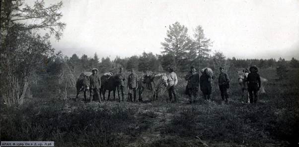
Fig. 1. Participants of the IKE of the USSR Academy of Sciences in the route, 1925. ARAN. F. 1569. Op. 2. D. 141. L. 26.
Work in the Shergin mine. As can be seen from the above, no special geocryological unit was created within the framework of the IKE of the USSR Academy of Sciences. There was no separate sub-unit of the corresponding orientation in its composition. Nevertheless, a number of works related to the scientific understanding of the phenomenon of "permafrost" have been completed. Thus, it was the activities of the participants of the IKE of the USSR Academy of Sciences that allowed them to make a certain contribution to the restoration of the Shergin mine. After the completion of A.F. Middendorf's research in Yakutsk, systematic observations in the mine ceased and it gradually declined. In 1928, on behalf of a meeting on permafrost research in the Yakut ASSR, work was carried out to determine the suitability of using the mine as an experimental basis for the establishment of a permanent permafrost station in Yakutsk. The work was led by Acting Head of the Yakut Geophysical Observatory, head of the aerometeorological detachment of the Yakut Academy of Sciences of the USSR V.A. Novsky [19, l. 1]. During the survey, the participants of the enterprise managed to inspect the shaft of the mine, to check the possibility of descending into it in the presence of technical equipment, which was then available in Yakutsk. In addition, separate observations were made during the examination. Some details of the work carried out are preserved in a letter written by V.A. Novsky and addressed to the scientific secretary of the Yakut Autonomous Soviet Socialist Republic (KAR) Commission for the Study of the Yakut Autonomous Soviet Socialist Republic (KAR), P.V. Wittenburg, who led the work of the Yakut Academy of Sciences of the USSR: "The descent into the mine was carried out twice, after a number of experiments confirmed that carbon dioxide in the mine missing. The first descent on August 26 was carried out in order to clear the shaft of the ice formed on the walls, which had to be done for the safety of further descents. With very primitive equipment, G. Gulin, a carpenter from the USSR Academy of Sciences, who took an active part in the work, descended into the mine and managed to reach the bottom with great risk. The descent was carried out in a bucket using a dilapidated wooden gate, the bucket was tied to a hemp rope, which was quite thick, but doubtful in its strength. The first descent showed that the mine was quite suitable for work, but the first descent also showed that further descents could not be carried out with our equipment. Gulin refused further descents" [19, l. 2]. The danger of the descent was that the gate intended for these purposes had become seriously dilapidated and loose by that time. In addition, the hemp rope, which was used during the descent, had previously been "used for river work for a long time" and was "pretty well protected." V.A. Novsky also pointed out another problem – the gate was very heavy for lifting a bucket with a person standing in it. As a result, it was necessary to attract 8 people for these purposes, who, nevertheless, "hardly turned the gate" [19, l. 2 vol.] (Fig. 2). 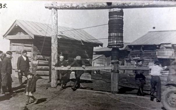
Fig. 2. The descent of the crate into the Shergin mine, Yakutsk, 1939. Photo by P. Borozdin. RGAE. F. 82. Op. 2. D. 98. L. 35. Despite the initial refusal, on August 30, 1928, Gulin again descended into the Shergin mine, which at that time was 99 m deep (part of the mine was filled with ice and logs). During the descent, he compiled a description of the shaft (dimensions at various depths, characteristics of soils at various depths up to 91 m). In addition, samples of ice and rocks were taken, also taken at different depths. Later, V.A. Novsky described them. At the same time, samples were taken for subsequent microbiological analysis. Gulin also measured the air temperature at depths of 10, 30, 50, 70, 90 and 99 m. For example, at a depth of 10 m, this indicator was -7.4 °C, at a depth of 50 m – -5.4 °C, at 99 m, when the thermometer was suspended from a nail against the wall, the temperature was -3.6 °C and -4.1 °C, when it was located on one of the stones that littered the lower part of the mine [19, l. 4-17 vol.]. After these two descents, V.A. Novsky "had to abandon the idea of immediately carrying out work on the organization of observations," including due to the rather high degree of risk and the fact that the equipment issued by the City Council for organizing the descent for temporary use had to be returned soon [19, l. 2 vol.]. Nevertheless, in order to conduct regular geothermal observations in the Shergin mine, electric tomographs were purchased [19, l. 39]. However, based on the information revealed so far, no such observations have been organized at the Shergin mine. It is quite possible that the position of the geologist S.G. Parkhomenko, who visited it in 1920, played a role in this. In his prepared article "On the issue of resuming geothermal observations in the Shergina mine," S.G. Parkhomenko was skeptical about the expediency of conducting such observations – the mine was flooded and filled up with earth. As a result, in his opinion, conditions have formed in it that are quite far from natural. In this regard, the scientist considered that "it is better to dig new mines," and the participants of the IKE of the USSR Academy of Sciences "should not focus only on geothermal observations, but keep in mind a comprehensive knowledge of the permafrost process" [19, l. 39-50]. Observations of thermokarst. It was not possible to organize such a comprehensive understanding of the phenomenon of "permafrost" within the framework of the IKE of the USSR Academy of Sciences, however, the participants of its detachments collected in the course of their research data that characterized various aspects of cryogenic processes, and also received information that allowed to some extent compare the relevant knowledge of the local population and emerging scientific ideas. In particular, N.V. Volens, head of the economic department of the National Academy of Sciences of the USSR, noted the following when carrying out surveys on the territory of the modern Amginsky ulus: "Leaving arable land in deposits for several years and, finally, abandoning it is widely practiced. In many cases, abandonment of arable land is absolutely inevitable. For example, where arable land cleared from under the forest, after several years of cultivation, gives sinkholes and forms ravines due to the melting of the subsurface ice – this is quite common" [1, l. 68].
Members of the agronomic detachment of the YAKE Academy of Sciences of the USSR, who also worked in the Lena-Amga interfluve, recorded the formation of thermokarst lakes (of "failed origin"), including what happened directly "before their eyes." At the same time, they noted that the population associated the formation of some of these lakes with clearing for arable land: "it is indicated that part of the clearing can be used for crops for only five to six years, after which the relief begins to change, depressions form in which water stagnates, and then the lake" [20, l. 26]. Thus, according to the local population, the stages of thermokarst development are described, which three decades later P.A. Solovyov outlined in his classic monograph: the formation of depressions (bylary) at the initial stage due to the removal of underground ice, which later combine, leading to the appearance of small lakes (dyuedya). Then, after several more stages, alas are formed – treeless flat hollows of rounded shape [22, pp.12-15]. One of the members of the K.A. Benois agronomic team, near the village of Byuteidyakh in the Meginsky ulus in the town of Bietek, managed to photograph a lake (Fig. 2), "formed at the site of clearing for arable land, produced 55 years ago – one of the first in the taiga – called Oxobutyakh (which means "a place of fighting", because according to legend has it that it was possible to plow after the owner overcame serious opposition from the rest of the population). The arable land in this place lasted only 15 years, after which it collapsed, and crucian carp are currently found in this lake" [20, l. 26]. 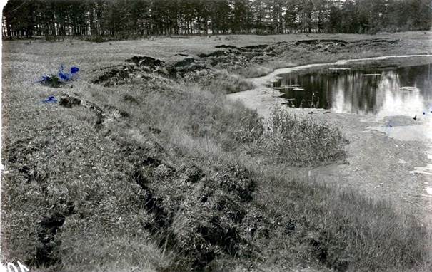
Fig. 3. Thermokarst development in the vicinity of Byuteidyakh village, Meginsky ulus, Yakutsk district, 1926 by K.A. Benois. Yagomiikns, YAGOM KPF-8540. In terms of assessing the extent of the spread of thermokarst, the following remark by researchers is characteristic: "It may not be significant so much, it is indicated by the population everywhere in this area" [20, l. 26]. It is also interesting that in this regard, scientists have managed to record the presence of a certain level of knowledge among the local population about the peculiarities of thermokarst development. Thus, in a report prepared based on the results of the surveys, it was noted: "This is explained by local elders (activation of thermokarst – A.S.) in such a way that as a result of the information, when clearing the forest, the soil warms up more strongly, the permafrost layer begins to melt from above and as a result the soil collapses and the water protrudes upward" [20, l. 26]. In terms of the accuracy of the noted folk knowledge, it is significant that it is precisely with the removal of the insulating ground cover and deforestation of the tree cover, resulting in a violation of the thermal balance regime of the earth's surface and its stronger warming under direct sunlight, that the authors of the monograph "Monitoring the thermal regime of the soils of Central Yakutia" associate the most intense temperature increases of the MMP, leading to a loss of their stability and the subsequent development of thermokarst [3, p. 144]. In terms of correlating the traditional knowledge of indigenous peoples about "permafrost" and the scientific understanding of the specifics of cryogenic processes that existed at the time of the IKE of the USSR Academy of Sciences, the conclusions drawn by the head of the soil suborder, Professor A.A. Krasyuk and his participant, G.N. Ognev, as a result of research conducted in the Lena-Amginsky interfluve in 1925. The researchers noted the widespread use of "alas spaces", which were "the most characteristic feature of this area" [15, p. 113]. The formation of alas, according to these authors, occurred "through sinkholes and subsidence of the soil," resulting from suffusion processes that occur "in the bowels of calcareous rocks (marl sandstones and limestones) underlying post-tertiary sediments." The researchers suggested that the sinkholes were formed under the influence of the "dissolving effect of groundwater." At the same time, the melting of "ice strata buried in post-tertiary sediments ..." could also have influenced the origin of the alas only "to some extent" [15, p. 118]. Thus, the example given shows that in the mid-1920s, the bearers of popular knowledge living in rural areas of Yakutia concerning certain aspects of cryogenic processes had even more accurate ideas, for example, about the genesis of thermokarst landforms, than individual scientists, including participants in the IKE of the USSR Academy of Sciences. This is not surprising, given that experts associate the separation of geocryology into an independent branch of scientific knowledge with the publication of the first specialized monograph, the work of M.I. Sumgin "Permafrost of soil within the USSR", which took place only in 1927 [27]. At the same time, the author of the preface to this monograph, P.I. Koloskov, called for "the destruction of permafrost by the combined efforts of science and technology" [25, p. VIII]. Among other folk knowledge recorded by the participants of the agronomic detachment of the Yakut Academy of Sciences of the USSR regarding the specifics of organizing agricultural activities on permafrost and the development of thermokarst, the "observation of Yakuts" is also of interest, which "shows that sinkholes form faster under dense small forests, and rarely for a longer time, which is explained by the varying depth of the permafrost layer" [20, L. 46]. In addition, again, according to data obtained from representatives of this named ethnic group, "the best places for arable land in the forest are "Charans", elevated dry places under a birch grove" [20, l. 46]. If the members of the agronomic detachment worked, as noted, on the territory of the Lena-Amga interfluve, i.e. in Central Yakutia, then A.I. Vorobyov and S.A. Nikitin, as part of the IKE of the USSR Academy of Sciences, conducted research on the state of agriculture and land use in the southern and southeastern regions of the region. On the territory of the modern Ust-Maysky district, they recorded the following picture: "as for the relief of the fields, it is generally quite leveled, in some places there is some variation in it due to the usual "failures" of clearing in Yakutia, explained by the thawing of permafrost" [21, l. 35].
Separate conclusions about the genesis of thermokarst landforms based on the results of research conducted within the framework of the IKE of the USSR Academy of Sciences were made by the head of a number of expedition teams, future academician of the USSR Academy of Sciences, geographer A.A. Grigoriev (Fig. 4). In particular, the materials collected during research in the basins of the Aldan and Vilyu districts in 1925-1926 allowed the scientist to hypothesize that the formation of alas is associated with the removal of firn ice formations [9, pp. 128-138]. In particular, he came to the following conclusion: "judging by the nature of the Aldan fossil ice ... the origin of these ice masses must be related to the recrystallization of snow" [9, p. 132]. Understanding of the role of re-vein ice removal in the formation of thermokarst relief came to geocryology only after a decade and a half. 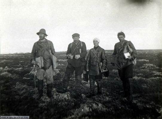
Fig. 4. A.A. Grigoriev (second from left) in the course of field research of the IKE of the USSR Academy of Sciences, 1925. ARAN. F. 1569. Op. 2. D. 141. L. 24. At the same time, it should be noted that A.A. Grigoriev also recorded a fundamentally correct understanding by the local population of the genesis of thermokarst landforms: "... the population of central Yakutia ... strongly points out that some lakes arose during the last century by melting the surface part of the earth's crust" [9, p. 132]. Conclusion Thus, despite the fact that during the Nuclear Power Plant of the USSR Academy of Sciences, including work at the Shergin mine, it was not possible to organize a systematic scientific study of the phenomenon of "permafrost", the expedition participants were able to obtain a set of information characterizing the features of some cryogenic processes, including thermokarst, through the prism of agricultural development interests. At the time of the research conducted by the IKE of the USSR Academy of Sciences, thermokarst was quite common on agricultural lands in Yakutia. The data recorded by the researchers allow us to draw conclusions about the significant activity of underground ice removal processes in the areas used for arable land in the first quarter of the twentieth century. It should be noted that interesting examples of traditional knowledge of representatives of local rural communities of Yakutia regarding cryogenic processes and, first of all, thermokarst have been preserved due to the scrupulousness of the participants of the IKE Academy of Sciences of the USSR. These examples indicate that, in some respects, the bearers of this knowledge at the time of the expedition had an even better understanding of the specifics of the formation of thermokarst landforms than representatives of the scientific community. In the future, this ratio will change quite quickly in favor of scientists, not only due to the development of geocryology, but also due to the loss of traditional knowledge by the rural population of Yakutia for a number of reasons. The noted development of geocryology was to a certain extent based on materials obtained during research conducted within the framework of the Yakut complex expedition of the USSR Academy of Sciences in 1925-1930, which testified to the need for a comprehensive study of permafrost not only for the effective development of agriculture, but also for optimizing construction, mining, transport development of Yakutia, etc.
References
1. Archive of the Russian Academy of Sciences. Fund 582. Inventory 5. Case 95.
2. Boyakova, S. I. (2018). Materials of the northern detachments of the Yakut expedition of the USSR Academy of Sciences 1925-1930 as a source for the history of scientific development of the Arctic. In Arctic and North in modern humanitarian studies: Collection of scientific articles (pp. 8-17). IGIiPMNS SO RAN. https://doi.org/10.25693/571.56.985.2018_002
3. Varlamov, S. P., Skachkov, Y. B., & Skryabin, P. N. (2021). Monitoring of the thermal regime of soils in Central Yakutia. IMZ SO RAN.
4. Vinokurova, L. I. (2022). The manuscript of I. P. Soikkonen in the context of studying the everyday winter life of the Yakuts in the first third of the 20th century. Oriental Studies, 15(3), 501-518. https://doi.org/10.22162/2619-0990-2022-61-3-501-518
5. Vinokurova, L. I. (2005). The researcher of Anabar P. V. Sleptsov: man and fate. In Anabar ulus: History. Culture. Folklore (pp. 87-94). Bichik.
6. Wittenburg, E. P. (2008). The Academy of Sciences Commission for the Study of Productive Forces of the Yakut ASSR (1925-1930): Organization and methodology of work. Bichik.
7. Wittenburg, P. V. (1925). Yakut expedition of the Academy of Sciences.
8. Goryushkin, L. M. (1996). The Yakut comprehensive expedition. Bulletin of the Russian Academy of Sciences, 5, 458-462.
9. Grigoriev, A. A. (1930). Morphology of the northeastern part of the Vilyui district: Report of the Vilyui detachment of the Yakut expedition of the USSR Academy of Sciences in 1926 under the leadership of A. A. Grigoriev. AN USSR.
10. Desyatkin, R. V. (2005). Soil studies of the Yakut expedition of the USSR Academy of Sciences in 1925-1930. Bulletin of the Yakut State University, 2, 20-24.
11. Ermolayeva, Y. N. (2005). M. K. Ammosov and the organization of the Yakut expedition of the USSR Academy of Sciences. Bulletin of the Yakut State University, 1, 12-16.
12. Ermolayeva, Y. N. (2001). The Yakut comprehensive expedition 1925-1930: Development of science in Yakutia. Nauka.
13. Zheleznyak, M. N., Klimovsky, I. V., & Shepelev, V. V. (2016). The contribution of academician A. F. Middendorff to the establishment of cryological science. In History of Earth Sciences: Collection of articles (Vol. 5, pp. 15-21). Akollit.
14. Kamensky, R. M. (1996). Permafrost studies of the Yakut expedition of the USSR Academy of Sciences. In Results and development of studies of the Yakut expedition of the Academy of Sciences: Materials of the scientific conference dedicated to the 70th anniversary of the establishment of the Yakut comprehensive expedition of the USSR Academy of Sciences (pp. 61-66). YNC SO RAN.
15. Krasyuk, A. A. (1927). Soils of the Lensko-Amginsky watershed (Yakut district): Report of the Aldan detachment of the Yakut expedition of the USSR Academy of Sciences in 1925 under the leadership of A. A. Grigoriev. AN USSR.
16. Middendorff, A. F. (1860). Journey to the north and east of Siberia. Part 1. Section 1. Printing House of the Imperial Academy of Sciences.
17. Nedrigailov, S. N. (1928). Forest resources of the Lensko-Aldan plateau and the Zaaldano-Verkhoyansk mountain region. AN USSR.
18. Nikolaev, V. P. (2006). Medical and sanitary detachment of the Yakut expedition of the USSR Academy of Sciences (1925-1926). Science and Education, 2, 133-136.
19. Saint Petersburg branch of the Archive of the Russian Academy of Sciences (SPbF ARAN). Fund 47. Inventory 1. Case 927.
20. SPbF ARAN. Fund 47. Inventory 2. Case 14.
21. SPbF ARAN. Fund 47. Inventory 2. Case 53.
22. Solovyov, P. A. (1959). Cryolithozone of the northern part of the Leno-Amginsky interfluve. AN USSR.
23. Solomonov, N. G. (2005). Zoological studies of the Yakut expedition of the USSR Academy of Sciences (1925-1930). Bulletin of the Yakut State University, 2, 37-42.
24. Suleymanov, A. A., Vinokurova, L. I., Lytkin, V. M., et al. (2024). Anthropology of cold: Natural low temperatures in the life support system of rural communities of Yakutia (traditional practices, modern challenges, and adaptation strategies). Nauka.
25. Sumgin, M. I. (1927). Permafrost of soil within the USSR. Vladivostok: DVGOU.
26. Fedorov, A. N. (2020). Evolution and dynamics of permafrost landscapes of Yakutia (Doctoral dissertation).
27. Shepelev, V. V. (2013). The founder of permafrost science, Professor M. I. Sumgin in Yakutia. Science and Technology in Yakutia, 2, 48-52.
28. Shirina, D. A. (2011). Activity of the geomorphological detachment of the Yakut academic comprehensive expedition in the context of the history of the Kolyma region 1929-1930. Northeast Humanitarian Bulletin, 2, 18-25.
29. Schreiber, S. E. (1931). Medical and sanitary examination of the population of the Vilyui and Oleksminsk districts. AN USSR.
30. Lytkin, V., Suleymanov, A., Vinokurova, L., et al. (2021). Influence of permafrost landscapes degradation on livelihoods of Sakha Republic (Yakutia) rural communities. Land, 10, 101. https://doi.org/10.3390/land10020101
First Peer Review
Peer reviewers' evaluations remain confidential and are not disclosed to the public. Only external reviews, authorized for publication by the article's author(s), are made public. Typically, these final reviews are conducted after the manuscript's revision. Adhering to our double-blind review policy, the reviewer's identity is kept confidential.
The list of publisher reviewers can be found here.
The reviewed text "The Yakut Complex Expedition of the USSR Academy of Sciences 1925-1930 and the study of permafrost" is devoted to some little-studied aspects of the activities of the Yakut complex expedition of the USSR Academy of Sciences in 1925-1930. and it is an interdisciplinary study (historical local lore, history of science, agronomy, ethnography, anthropology of cold) based on an impressive source base (archival materials from the archives of Moscow, Yakutsk, St. Petersburg, published materials of the Yakutsk Academy of Sciences of the USSR, field research by the author, etc.). The author points out that in the presence of an extensive set of studies covering different aspects To a certain extent, the understanding of the phenomenon of the Yakut permafrost and its degradation remains a "blank spot" in the activities of the Yakut Academy of Sciences of the USSR, which in modern conditions of climatic transformations ("global warming") gives the study significant relevance. The author explains the research methodology of the author's concept of "anthropology of cold" ("cold" matters of the Earth not only as a challenge, but also as a source of additional opportunities for the population of the northern territories), however, in the context of this work, it is rather not a methodology, but one of the aspects of the interpretation of the data obtained, one of the components of interdisciplinary research, the methodology is in historical and archival critical analysis, comparative analysis, etc., based on the nature of the source base of this research (reports, etc. IKE documents, letters from participants, etc.). Based on the stated logic, the author aims to study the process of accumulation of scientific data on permafrost and its transformation by the participants of the IKE of the USSR Academy of Sciences. The author identifies two main subjects in the works of the expedition of the USSR Academy of Sciences: work (diving) in the Shergin mine in 1928 and surveys of the local population /observations of the state of thermokarst soils; in both cases, the objectives, methods and results of the research are described. The text is accompanied by archival photographs. The author comes to the logical conclusion that within the framework of the Yakut Academy of Sciences of the USSR, a deep and systematic study of the phenomenon of Yakut permafrost was not organized, work at the Shergin mine was actually interrupted and considered impractical, the study of soil conditions was more effective, and it is here that the ethnographic nature of the research is manifested (traditional knowledge of local residents about the dynamics of the state of agricultural land). It is obvious that the study of permafrost was not one of the priorities of the YCE, the results of its activities in this area, as shown by the author, are rather modest; nevertheless, consideration of the above-mentioned plots allows us to close the conditional "white spots" in the activities of the YCE of the USSR Academy of Sciences. The inclusion of research materials in the modern discourse on climate transformations and the anthropology of cold is also a valuable outcome of this work. The work is recommended for publication.
Second Peer Review
Peer reviewers' evaluations remain confidential and are not disclosed to the public. Only external reviews, authorized for publication by the article's author(s), are made public. Typically, these final reviews are conducted after the manuscript's revision. Adhering to our double-blind review policy, the reviewer's identity is kept confidential.
The list of publisher reviewers can be found here.
The history of science allows us to evaluate not only scientific achievements, but also the true heroism of research scientists. Indeed, let us mention here the medieval doctors who dissected corpses in cemeteries under the cover of night, and let us not forget about the exploits of the polar travelers, the same death of R. Scott's group. But there are also areas in Russia that are truly extreme, we mean the regions of the Far North. In this regard, it is of interest to study various aspects of the history of scientific expeditions to the polar regions of our country. These circumstances determine the relevance of the article submitted for review, the subject of which is the Yakut complex Expedition of the USSR Academy of Sciences in 1925-1930. The author sets out to analyze the nature of the expedition, to identify the information that the expedition was able to collect. The work is based on the principles of analysis and synthesis, reliability, objectivity, the methodological basis of the research is a systematic approach based on the consideration of an object as an integral complex of interrelated elements. The scientific novelty of the article lies in the very formulation of the topic: the author seeks to characterize the issues of studying permafrost during the Yakut complex expedition in the second half of the 1920s. Scientific novelty is also determined by the involvement of archival materials. Reviewing the bibliographic list of the article, its scale and versatility should be noted as a positive point: the total list of references includes 30 different sources and studies, which in itself indicates the amount of preparatory work that its author has done. The source base of the reviewed article is represented by documents from the collections of the Archive of the Russian Academy of Sciences and the St. Petersburg branch of the Archive of the Russian Academy of Sciences, the works of the polar scientist P.V. Witenburg, etc. From the studies used, we will point to the works of Yu.N. Ermolaeva and N.G. Solomonov, who focus on various aspects of studying the history of the Yakut integrated expedition. Note that the bibliography is important both from a scientific and educational point of view: after reading the text of the article, readers can refer to other materials on its topic. In general, in our opinion, the complementary use of various sources and research contributed to the solution of the tasks facing the author. The writing style of the article can be attributed to the scientific, but at the same time accessible not only to specialists, but also to a wide readership, to anyone who is interested in both polar research in general and the Yakut integrated expedition in particular. The appeal to the opponents is presented at the level of the information collected, obtained by the author during the work on the topic of the article. The structure of the work is characterized by a certain logic and consistency, in it one can distinguish the introduction, the main part, and the conclusion. At the beginning, the author defines the relevance of the topic, shows that one of the "little-studied pages in the history of research within the framework of the IKE of the USSR Academy of Sciences are works related in one way or another to the understanding of the phenomenon of permafrost (MMP, "permafrost")." The paper shows that the data collected by the researchers "allow us to draw conclusions about the significant activity of underground ice removal processes in areas used for arable land in the first quarter of the twentieth century." It is noteworthy that, as the author of the reviewed article notes, "the bearers of popular knowledge living in rural areas of Yakutia concerning some aspects of cryogenic processes in the middle In the 1920s, they had even more accurate ideas, for example, about the genesis of thermokarst landforms, than individual scientists, including participants in the IKE of the USSR Academy of Sciences." The main conclusion of the article is that "information characterizing the features of some cryogenic processes, including thermokarst, through the prism of agricultural development interests." The article submitted for review is devoted to a topical topic, is provided with 2 drawings, will arouse reader interest, and its materials can be used both in lecture courses on the history of Russia and in various special courses. In general, in our opinion, the article can be recommended for publication in the journal "Arctic and Antarctic".
|


