|
Security Issues
Reference:
Degterev A.K.
The Problem of the North Crimea Canal as a Cross-Border Conflict on the Dnieper River
// Security Issues.
2022. ą 4.
P. 128-135.
DOI: 10.25136/2409-7543.2022.4.39461 EDN: YFGAYA URL: https://en.nbpublish.com/library_read_article.php?id=39461
The Problem of the North Crimea Canal as a Cross-Border Conflict on the Dnieper River
Degterev Andrey Kharitonovich
Professor, Department of Radioecology and Environmental Compliance, Sevastopol State University
299033, Russia, Sevastopol', g. Sevastopol', ul. Kurchatova, 7

|
degseb@yandex.ru
|
|
 |
Other publications by this author
|
|
|
DOI: 10.25136/2409-7543.2022.4.39461
EDN: YFGAYA
Received:
20-12-2022
Published:
30-12-2022
Abstract:
The North Crimean Canal is considered as a continuation of the Dnieper River. This makes it possible to analyze its overlap in 2014 as one of the classic problems of transboundary water use associated with partial or complete restriction of flow in the middle or lower reaches of the river. As a similar example, the conflict between Turkey and Syria over the water resources of the Euphrates River is considered. It is shown that such cross-border conflicts are often caused by both economic reasons and arise in connection with a decrease in runoff in some years due to increased aridity of the climate. This article presents game-theoretic models of interaction between the parties and substantiates the need for compensation payments between the countries participating in a cross-border dispute. Based on the results of the analysis carried out in this article, it was concluded that one of the consequences of the possible destruction of the dam of the Kakhovsky reservoir will be the cessation of water supply to the North Crimean Canal. The fact is that in the first section with a length of more than 200 km, water from the reservoir flows into the channel by gravity, so that when the level drops at the water intake point by 16 m, the filling of the channel will stop.
Keywords:
Dnieper, Euphrates, North Crimean Canal, conflict, dam, reservoir, hydropower, game theory, waterworks, irrigation
This article is automatically translated.
One of the manifestations of the growing shortage of fresh water [5] is the increasing conflicts related to water use on transboundary rivers. It is no coincidence that in 2011, UN Secretary-General Ban Ki-moon said that the world is on the verge of "water wars". Especially often such conflicts occur on cross-border rivers. In a sense, from this point of view, we can also consider the problems that arose with the supply of Dnieper water to Crimea after its reunification with Russia in 2014. In February 2022, by undermining the dam that blocked the canal, the work of the North Crimean Canal (SKK) was resumed. From October 1963 to April 2014, this channel allowed solving a whole range of important national economic tasks. After its solemn commissioning in the presence of N.S. Khrushchev, by blowing up an auxiliary dam in the Crimea, the harvested wheat harvest increased 5 times due to irrigation, the population in the Northern Crimea increased 4 times. Until 2014, the North Crimean Canal provided water supply to Crimea by more than 80%. So, in 2013, 1.6 km3 of water was supplied through it, with the total flow of all rivers of Crimea 0.4 km3/year [1]. The water intake of the CCM is located on the Kakhovsky reservoir, from where water is supplied by gravity through the Perekop Isthmus at a distance of 208 km to the first pumping station at Dzhankoy, that is, already on the territory of the Crimea. The length of the CCM reaches 402 km, so that by its scale it may well be considered an artificial river, one of the branches of the Dnieper River. The Dnieper itself is a cross–border river before this branch, in the upper reaches it flows through the territory of Russia and Belarus, in the middle and lower reaches - through the territory of Ukraine. At the same time, Ukraine accounts for 48% of the length of the riverbed, that is, less than half. It is also important to note that already in the upper catchment area, which makes up 65% of the total area of the river basin, up to 80% of its annual runoff enters the Dnieper. In terms of transboundary water use, some details related to the construction of the CCM are also important. The fact is that it was conducted even before the transfer of the Crimea to the Ukrainian SSR in the spring of 1954. In accordance with Resolution No. 4000 of the Council of Ministers of the USSR dated 09/20/1950, signed by its Chairman I. Stalin [1], the construction of the Kakhovsky hydroelectric complex began in 1950. In 1952, after the earthen dam was washed, concrete was already laid, and in 1954 the first turbine of the Kakhovskaya hydroelectric power station was installed. Moreover, this very Resolution of the Council of Ministers, which initiated the construction of the CCM, was called "On the construction of the Kakhovka hydroelectric power station on the Dnieper River, the South Ukrainian Canal, the North Crimean Canal and on irrigation of the lands of the southern regions of Ukraine and the northern regions of Crimea." According to the Resolution of the CCM, it was a continuation of the South Ukrainian Canal, designed for water intake from the Dnieper of 0.6 thousand m3/s. This corresponds to about a third of the flow of the Dnieper. The project provided for the expansion of the area of irrigated land not only in the Crimean region of the RSFSR, but also in four regions of Ukraine (Kherson, Zaporozhye, Mykolaiv and Dnepropetrovsk). Thus, then the issue was solved precisely as the transfer of part of the waters of the Dnieper from the territory of Ukraine to the territory of the Russian Federation. Later, in the 1960s – 1970s, in addition to the Kakhovskaya HPP and the Dnieper HPP, a whole cascade of HPPs with an installation capacity of 4 GW was built on the Dnieper (Fig. 1), which was a unique complex of hydraulic structures, the pride of the USSR. It was visited by many foreign delegations, including from Turkey. In the seventies of the 20th century, the future President of Turkey Recep Tayyip Erdogan also came here, who was greatly impressed by the Kakhovka reservoir and the Dnieper hydroelectric power station. As he himself later said, under the influence of these impressions, a similar grandiose hydraulic engineering project was subsequently implemented under his leadership on the Euphrates River in southeastern Turkey (Fig. 2). 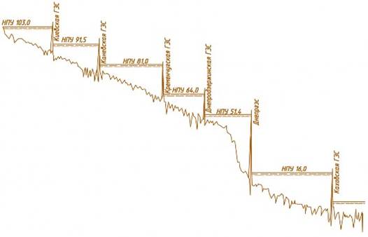
Fig. 1. Cascade of hydroelectric power plants and reservoirs on the Dnieper. The figures indicate the rise of the water level by dams of reservoirs. There is indeed a great analogy between these two projects, including in terms of transboundary water use. Both rivers have similar annual runoff values – the Dnieper has 52 km3/year, the Euphrates has 30 km3/year. The catchment areas are also comparable: 504 thousand km2 and 673 thousand km2. Moreover, the Euphrates, like the Dnieper, has the main catchment in the upper reaches (in the mountains of Turkey). Both there and there the river flows through the territory of three states – Russia, Belarus, Ukraine in the case of the Dnieper and Turkey, Syria and Iraq in the case of the Euphrates. There is, of course, a difference: the main cascade of hydroelectric power plants and reservoirs on the Euphrates (GAP project) is implemented in the upper reaches, on the territory of Turkey (Fig. 2). In addition, the operation of the CCM is not year-round: its filling usually began at the end of March, and in November the water supply was completed due to the onset of frosty period. Nevertheless, the analysis of the relationship between the countries in connection with their use of the water resources of the Euphrates in its middle and lower reaches in the context of the problem of the North Crimean Canal is of obvious interest. 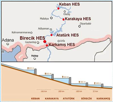 Fig.2. Cascade of hydroelectric power plants and reservoirs built by Turkey on the Euphrates At first, back in the 70s of the twentieth century, there were problems in the field of water use between Syria and Iraq. Then in Syria, with the technical support of the Soviet Union, the Tabka hydroelectric power station and the Al–Assad reservoir with a volume of 12 km3 were built. At the same time, the Euphrates was blocked by an earthen dam with a height of 40 m, after which it took four years to fill the reservoir, from 1973 to 1976. Then more than half of all Syrian electricity was generated at this hydroelectric power plant, further plans were being developed for the construction of a cascade of dams, reservoirs and hydroelectric power plants in Syria.
However, already in 1975, Iraq threatened to bomb the dam, because due to the filling of the Al-Assad reservoir, the water level in the Euphrates River in Iraq fell to critical. In fact, an ultimatum was announced to Syria – to immediately open the spillway at the dam, otherwise the dam will be destroyed by Iraqi aviation. It did not come to war then, with the help of intermediaries in the face of the USSR and Saudi Arabia, the conflict was settled. The parties agreed that Syria will compensate Iraq for the decrease in the flow of the Euphrates by supplying electricity from the Tabqa hydroelectric power station. That is, even then, in the 1970s, the construction of a powerful hydroelectric power plant led to serious international problems related to transboundary water use in the region. And in the early 1980s, Turkey itself began to build a cascade of reservoirs and hydroelectric power stations on the Euphrates [6]. Suffice it to say that according to this plan, which is called the South-Eastern Anatolian Project (GAP), it was planned to build 22 dams and 19 hydroelectric power plants by 2040, and their total capacity will be an order of magnitude greater than that of the Tabka hydroelectric power plant. And already in the 1980s, the largest Kemal Ataturk dam in Turkey (named after the former president of Turkey) was built on the Euphrates. In the 1990s, when filling the reservoir, the flow of the Euphrates was completely blocked for a month for Syria itself. After the construction of this dam, Turkey continued to regulate the spillway through it and build new dams. When the flow restriction was imposed on a dry year, the consequences for the agriculture of Syria were catastrophic [2]. The fact is that in a low-water year, the flow of the Euphrates, even for natural reasons, decreases three times. Because of this, as of 2011, millions of Syrians migrated from northern Syria, abandoning their homes and land plots. By 2001, 19 dams had been built in Turkey, and it began to receive a large amount of cheap electricity at the expense of new hydroelectric power plants. It is well known that Turkey has already blocked 30% of the water flow to Syria and 50% to Iraq, and upon completion of the project, the flow of the Euphrates in Syria will decrease by an average of 40%, and the Tigris and Euphrates in Iraq – by 80%. At the same time, Turkey has increased agricultural production by 2.5 times by attracting new irrigated lands. Repeated attempts were made to regulate the "water relations" of Syria with Turkey, and in 1987 a temporary agreement was concluded, according to which Turkey undertook to allow at least 500 m3/s of water into Syria. It was later registered in 1994 at the UN. However, in fact, Turkey passes only 200 m3/s, and sometimes completely blocks the Euphrates for 1-2 months. So it was, for example, in May of the same 2014, when the water level in the Al-Assad reservoir fell by 7 m, and the water left the wells altogether. As recently as January 2021, Turkey reduced the flow of Euphrates water entering Syria by 60%, which led to a narrowing of the channel by 300 m. And this, among other things, hinders the operation of water intakes. In 1992, the UN adopted the Convention on Transboundary Water Resources, in 1997 – the Convention on the Use of International Waterways. But Turkey has not signed it. On the basis of internal documents, Turkey adheres to the principle of "more harvest per unit of water" at the basin level for the Tigris and Euphrates rivers in matters of transboundary water use. In part, this can be understood, in the driest periods (1988-1989, 2007-2008), the flow rate of the Euphrates generally fell to 50 m3/s. Naturally, in such years, Turkey, with all its desire, cannot provide a transit flow of 500 m3/s. When analyzing conflict situations, game theory is usually used, and symmetric games are usually considered. These are, for example, games related to the construction of dams on the river that protect against flooding [3]. There, both players have two strategies – to build or not to build a dam. In our case, one side decides to block the flow or not, and the other – to destroy or not to destroy the dam. That is, the players now have different strategies, the game is not symmetrical. Let the construction of the dam cost the first player 2 billion. conventional units (CU) and then he received a benefit of 4 billion CU from this. Then his net gain will be 2 billion CU. In turn, we will assume that by reducing the flow to the second player (the country downstream) this construction causes damage to 1 billion USD. And he decides whether to destroy the dam or not. If it does not destroy, its gain is -1 billion units. If it spends 0.5 billion units and destroys the dam, then its net gain will coincide with these costs and will be minus 0.5 billion units. And this is better than minus 1 billion units when choosing a strategy "do not destroy." The winning of the first player in this case is equal to the cost of building a dam. As a result, we get the matrix of the game, presented in Table. 1. There is no Nash equilibrium point in it, if the dam is built, it will be destroyed. Table 1. Matrix of the game without compensation | | | 2nd playerDo not destroy | | | | | To destroy |
| 1st playerDon't build | | (0, 0) | | | Build | (2, -1) | (-2, -0,5) | The way out is that the first player has to share part of his winnings. This is achieved by a compensation payment of at least 0.5 CU on the part of the first player. So, with a payment of 1 billion USD, the net winnings of players for a pair of "Build – not destroy" strategies will already be (1, 0). As can be seen from Table 2, now this pair of strategies is Nash equilibrium. Moreover, the second side then loses nothing at all from blocking the river. And the common good (the sum of the parties' winnings) as before, it increases by 1 billion units compared to the "zero" option. Table 2. Matrix of the game with compensation | | | 2nd playerDo not destroy | | | | | To destroy | | 1st playerDon't build | | (0, 0) | | | Build |
(1, 0) | (-2, -0,5) | In this version of the game, political factors were not considered. In fact, they also take place, for example, when the North Crimean Canal was closed in 2014, it was the political factor that was decisive. And Turkey still often uses the partial overlap of the Euphrates to prevent the Kurds from gaining a foothold in northern Syria. It is known that even at the stage of construction of the main dam in Turkey, several Kurdish towns and villages in Turkey itself fell into the flood zone, which led to the resettlement of 78 thousand people. Another example of a political solution is the closure of the Euphrates on February 23, 2017, immediately after the liberation of Aleppo from ISIS. As a result, the city was left without water and electricity supply (the hydroelectric power station was stopped). Interestingly, just before the closure of the CCM by Ukraine in the spring of 2014, negotiations were held on raising tariffs for water supply to the Crimea. This corresponds to a game in which the first player had strategies to skip – not to let water into the Crimea, and the second player – to agree or not to agree to new tariffs (Table 3). In fact, this is just blackmail, that is, the demand for a reverse compensation payment in the amount of 0.5 billion USD under the threat of overlap water. At the same time, if the second player refused to increase the tariff, the first player lost the previous income in the amount of 1 billion units, and the second suffered losses in accordance with Table 1. Table 3. Matrix of the game with reverse compensation | | | 2nd playerAgree | | | | | Disagree | | 1st playerSkip | | (0,5, -0,5) | | | Do not skip | (-1, -1) | (-1, -1) |
In this game, it is more profitable for both sides to skip a couple of strategies – to agree. And indeed, on March 19, 2014, the CCM began to fill up, as in previous years. However, on May 7, the canal was blocked 15 km from the border with Crimea. Political factors have become decisive. At the same time, the opening of the CCM in February – March 2022 during a Special Military Operation fully corresponds to the game described in Table 1. In turn, one of the consequences of the possible destruction of the dam of the Kakhovsky reservoir will be the cessation of water supply to the North Crimean Canal. The fact is that in the first section with a length of more than 200 km, water from the reservoir flows into the channel by gravity, so that when the level at the water intake point drops by 16 m (Fig. 1), the filling of the channel will stop. But this situation requires a separate analysis.
References
1. Bogutskaya, E.M., Kositsky, A.G., Aibulatov, D.N., Grechushnikova, M.G. (2020). Average long-term runoff of the rivers of the Southwestern part of the Crimean Peninsula. Water Management of Russia. No. 2.-P.37–51.
2. Degterev, A.Kh. (2020). Climate change in Crimea over the past decades // Security Issues. No. 2.-P.1–6.
3. Degterev, D.A. (2016). Game-theoretic approach in law. M.: URSS, – 240 p.
4. Egorov, V.N., Malakhova, L.V., Degterev, A.Kh., Yurlov, M.N. (2021). The Mediterranean Sea Basin as a Single Ecosystem: Problems and Prospects for International Cooperation. Vestnik RUDN University. Series: International relations. V.21, No. 4. – P.625–641.
5. Kokorin, A.O. (2014). Climate change: a review of the Fifth Assessment Report of the IPCC / A.O. Kokorin. – M.: World Wildlife Fund (WWF). – 80 p.
6. Rysbekov, Yu.Kh., Rysbekov, A.Yu. (2015). Water management in Turkey / Yu.Kh. Rysbekov, A.Yu. Rysbekov. Tashkent: SIC ICWC.-52 p
Peer Review
Peer reviewers' evaluations remain confidential and are not disclosed to the public. Only external reviews, authorized for publication by the article's author(s), are made public. Typically, these final reviews are conducted after the manuscript's revision. Adhering to our double-blind review policy, the reviewer's identity is kept confidential.
The list of publisher reviewers can be found here.
The subject of the peer–reviewed study is conflicts over transboundary water use, specifically, the supply of the Crimean Peninsula with water from the Dnieper River through the North Crimean Canal. Given the history of the last 8 years, when, after the annexation of Crimea to Russia, it was deprived of water resources obtained from the Dnieper and provided 80% of its needs, the relevance of the chosen topic can hardly be overestimated. The author's methodological choice also seems to be quite adequate: to use the game theory, which has proven itself well in international relations studies, to analyze possible strategies of actors in conflict over the supply of water (or the construction of a dam blocking it) to Crimea. In addition, the work uses elements of a case study - a comparative analysis of two cases of conflicts over transboundary water use – Turkish (a hydraulic engineering project on the Euphrates River) and Ukrainian (a cascade of hydroelectric power plants and reservoirs on the Dnieper). The correct application of this methodology allowed the author to obtain results with signs of scientific novelty. First of all, it is very interesting to conclude that the closure of water by Ukraine to Crimea was not rational from an economic and strategic point of view, it was dictated solely by political considerations. It is also interesting to conclude that the result of the game (at this iteration) was a return to the matrix of the game without compensation. Structurally, the work also makes a positive impression. Although the rubrication of the text would not hurt. Conditionally, the following sections can be distinguished in the text: - the introductory part, where the scientific problem is formulated, its relevance is argued, but, unfortunately, there is no theoretical and methodological reflection, as well as setting goals and objectives; - the historical part, which describes the history of the construction and commissioning of the North Crimean Canal; - comparative analysis water use cases from the Euphrates River (Turkish-Syrian) and the Dnieper River (Ukrainian-Crimean); - analysis of strategies of actors participating in the game for the construction of a dam blocking the supply of water to the North Crimean Canal. Unfortunately, there is practically no final part in the work, which would summarize the results of the study and draw conclusions; the author literally casually outlines a retrospective of further research of the games on the destruction of the Kakhovsky reservoir dam, and is limited to this. The style of the reviewed work also does not cause any particular complaints: with the exception of a few minor blemishes, the text is written competently, in a good language, with the correct use of scientific terminology. The bibliography includes 6 titles and sufficiently represents the state of research on the subject of the article. There is no appeal to the opponents due to the applied nature of the article. GENERAL CONCLUSION: the article proposed for review can be qualified as a scientific work that meets all the requirements for works of this kind. The author has the skills to apply scientific methodology, the conclusions he obtained during the research are reliable and have signs of scientific novelty. The presented material corresponds to the topic of the magazine "Security Issues". The results of the conducted research will arouse the interest of political scientists, sociologists, specialists in the field of public administration, security, world politics and international relations, as well as students of the listed specialties. According to the results of the review, the article is recommended for publication.
|


